Showing posts with label continental glacier. Show all posts

Tuesday, August 20, 2019

Travels in Cascadia: Victoria B.C., the City of Mutton Rocks


The next stop in our recent travels through Cascadia was the city of Victoria on Vancouver Island in British Columbia. We got there by way of a ferry from Port Angeles, Washington, as described in the last post. Victoria is an attractive city, one of the most temperate in Canada, given its location on the Pacific shoreline (the adjacent ocean moderates the seasonal temperature extremes). It is also unique in another respect. The city is partially constructed on bedrock (the solid rock that underlies surface soils and sediments), and the land was under a vast 1,000 meter thick ice sheet only 14,000 years ago.

This geologically unique combination means that Victoria is sort of a city of mutton rocks.

I imagine that sentence needs explanation...

The term roche moutonnée describes an asymmetrical glacially scoured rock outcrop that has a smooth slope on the side facing the flowing ice, and a steep cliff on the side where the glacier pulled away from the outcrop ("stoss and lee structure" is a related term). The scale can range from a few meters to many hundreds. They are common features in regions of bedrock that have been scoured by massive continental ice sheets, such as happened in Victoria. One of the tallest hills within the city, Mt. Tolmie (below), is an excellent example. In the picture one can see the gently sloping forested flank on the left side of the hill, and the steeper plucked side to the right.
Mt. Tolmie, a roche moutonnée in Victoria

The problem with roche moutonnée as a geological term is that we geologists can only barely agree on its meaning. It's derived from French, and the "roche" part isn't a problem. It means "rock". But "moutonnée" is the tricky aspect. It can be translated loosely as "sheep" (think "mutton""), but not exactly (French: "mouton"). Moutonnée (with the extra e's) translates to "frizzy", and is taken as a reference to sheep's wool. The term originated in the 1700s with a naturalist named Horace-Bénédict de Saussure (it would be decades before the term "geologist" was coined) who noted that the rocks looked like a type of wig apparently well-known at the time whose locks were held in place with mutton grease. Except that there seem to be few or no references to wigs that were actually called that (the closest version was a tête de mouton).

So we teachers are left with trying to define the term as meaning "rock sheep" based on the nebulous idea that the rocks look like sheep grazing in meadows. Which they really don't. But it's still easier than trying to describe obscure French wigs from the 1700s and mutton grease.

There are consequences to building on such rocky landscapes. There are plenty of large patches of glacial till that are easy to plane off with a bulldozer for building construction, but when the rock crops out, allowances have to be made. Perhaps it might involve blasting to construct a flat foundation. The rock is pretty tough stuff, gabbro, diorite, and greenstone of the Wrangellia terrane, dating back to the era of dinosaurs.

There are problems in this kind of situation. When the Empress Hotel (see the picture above) was constructed in 1904-1905 it was placed partly on solid rock and partly on mud-rich sediments. Complications quickly ensued. The south part of the building subsided several centimeters within the first year and ultimately sank about a meter. It's a real headache for those who must maintain the building.

Still, Victoria is a truly beautiful city, and the city has a unique personality. The city has miles of coastline, and there are dozens of scenic shoreline parks. We pulled up at Cattle Point to look at smaller roches moutonnée along with glacial scour marks and striations. Strangely enough, there was a piano sitting on the bluff. It was brightly painted, there was a bench, and the piano was in tune! I wondered what was going to happen to it if it rained, but then noticed a waterproof cover. We later found that there are five such pianos in the parks, and we were actually treated to a tune by a passing jogger, followed by a song by one of our students!

If you ever have a chance to visit Victoria, enjoy the city, but be sure to follow the shoreline drive to see the glacial heritage of the landscape (as well as seeing some dramatic coastal scenery). But the other thing you should do is to hike or drive to the summit of the mutton rocks of the city. Mt. Tolmie is a good choice within the city limits, or you can go just north of the city to the much higher summit of Mt. Douglas. It's a short hike from the parking lot to a summit with a 360 degree view of the region. The Olympic Mountains are visible across the Strait of Juan de Fuca to the south beyond the city, and the many islands of the Strait of Georgia and Saanich Inlet are visible to the north and east. Glacial polish, striations and grooves are present underfoot.

On the day we were there, I saw some unusual looking clouds far to the southeast. I took a few highly zoomed shots and forget about them until weeks later. I started working with the contrast and exposure of the picture and realized I had captured an image of Mt. Rainier across the Puget Sound. The volcano is more than 130 miles away (below)!

I had three main resources for the geology in and around the city:
The Geology of Southern Vancouver Island by Chris Yorath
Roadside Geology of Southern British Columbia by Bill Mathews and Jim Monger
Geology of British Columbia, A Journey Through Time by Sydney Cannings, JoAnne Nelson, and Richard Cannings.

Wednesday, October 15, 2014

Northern Convergence: We'll Call it "Rock": The Okotok Erratic

There is a big rock out on the high prairie near Calgary, Alberta. That all by itself is a bit of strangeness. It's even more strange because it is around a hundred miles (160 km) from the cliff in which it originated, up in the Rocky Mountains in Jasper National Park. The Blackfoot Indians had a creative name for the rock, Okatok, which in their language means, um, "rock". These names always sound better in the original language! For whatever reason, the spelling changed a bit to Okotok.
The Blackfoot people had a great story for how the rock got to this spot, a myth that could have served as the inspiration for the rock monster in the movie "Galaxy Quest". Their legendary trickster Napi was resting on the rock on a hot day, so he left his cloak on the rock, saying "Here, I give you my robe, because you are poor and have let me rest on you. Keep it always". Murphy's Law dictates that it soon got cold, and the rain began, so Napi asked for the return of his robe. The rock refused so Napi grabbed "his" cloak. In a moment, the rock was up and running after him! Napi called on his animal friends, the Bison, Antelope and Deer, and none of them could stop the gigantic rock. When all seemed lost, a bat flew straight at the rock, collided with it, and the rock was split in two! The bat had saved Napi, and got a squashed face for all his trouble (such things have to be explained somehow...).*
A smaller erratic a few hundred yards from the Okotok Erratic
The geologists tell a different story, and were it not for the overwhelming evidence it would seem just as fantastical. During the Pleistocene Ice Ages, the continental ice sheets covered all of the region thousands of feet deep. Up in the Rockies at Jasper a huge rock slide dumped massive boulders onto the surface of the glaciers emanating from the high peaks. The glaciers flowed eastward onto the High Plains, eventually meeting up with the vast ice sheet that originated near Hudson Bay. The two ice sheets didn't mix, so the two "rivers" of ice flowed together towards the south. The gigantic rocks from the cliff in Jasper were dumped in a line many miles long where the glaciers moved together. These isolated boulders are called glacial erratics.
The rock is sometimes claimed as the largest erratic boulder in the world, but I have no way to evaluate the claim. It certainly is huge, and worthy of a visit (it is a few miles southwest of Calgary). The Blackfoot or other First Nation peoples were certainly impressed. Faint pictographs can still be seen on the flanks of the rock.
Pictographs are symbols painted on the rock. Petroglyphs are chipped into the rock.

This is a continuation of our Northern Convergence tour of British Columbia and Alberta. In this case, I guess "convergence" refers to the two masses of glacial ice. We concluded our visit and headed back towards the Rocky Mountains and Crowsnest Pass to check out a not-so-long-ago tragedy. More on that next time.

*The Blackfoot legend is  loosely rephrased from interpretive signs at the park.

Saturday, August 16, 2014

Northern Convergence: Victoria, Finding Geology and a Rare Ecosystem in a Beautiful City


We start our blog journey through Canada with a view of alpine peaks, forests and birds. If the picture seems a little fuzzy, it's because it is a highly cropped view down one of the main avenues in the city of Victoria on Vancouver Island (below). And truth be told, the peaks are actually in the United States. They are the Olympic Mountains, across the Strait of Juan de Fuca. We had not gone far into Canada yet!

Victoria is a pretty little city (population around 80,000, with a suburban population of about 340,000) that feels a little like it was carved from a wilderness, being surrounded by deep forests and rocky shorelines. All cities are imposed on geology, and Victoria is a vivid example. Just 12,000 or 13,000 years ago, the entire region lay beneath thousands of feet of glacial ice.
Glacial landscapes are exceedingly uneven, and the city's most venerable building is a victim of that fact. The Empress Hotel, constructed in 1908 (and no, we didn't get a chance to have High Tea there), has settled unevenly because portions are built on bedrock and the remainder on looser soils. As a consequence, one part of the foundation is a full meter lower than the other.

I suppose it is useless to point out the "Victorian architecture" when we are discussing a visit to Victoria, but the city was one of the oldest British settlements on the west coast of North America (1843), and the city has kept the flavor of old Britain (although most of our restaurant servers had Aussie accents or mentioned that they spent time living in Modesto!). Carriage rides are a staple of the tourist trade, and the city parks have tried to replicate the kind of flower gardens found in London, but the geology in some ways refuses to cooperate: glaciers didn't cover London, but they covered Victoria. Irregular knobs of bedrock pop out everywhere, and in those spots the park engineers surrendered to nature. Beacon Hill Park was our first geologic stop on the second morning of our trip.

The rocks themselves are quite unlike the rocks found across the Strait in Olympic National Park. Instead of deposits formed deep inside a subduction zone complex, the rocks exposed in Beacon Hill Park are metamorphic rocks derived from gabbro and granodiorite, a mixture called a migmatite. These rocks are derived from deep in the crust. They may date to 200 or 400 million years ago. 

The rocks were abraded by the glaciers, forming small roche moutonnées or crag and tail features. Such rocks are smoothed off on one side and plucked on the other, forming an asymmetrical linear ridge.

It occurred to me that the natural areas of the park were dry and out of character compared to other parts of the northwest coast of America, a place I associate more with rainforests. And there were oak trees, something I've never associated with western Canada. I thought that the northwest was all about conifers. It turned out that we had stumbled on one of the rarest biologic entities in Canada, the Garry Oak Ecosystem. Yes, it's really called that. The Garry Oak (Quercus garryana) is the only native oak species found in Washington and British Columbia.

Victoria is the driest locality on the west coast of Canada, averaging only about 24 inches of precipitation a year, with little and sometimes no snow. The local climate benefits from the moderating effect of the Pacific Ocean and Strait of Juan de Fuca, and lies in the rain shadow of the Olympics and other coastal mountains. Douglas Fir could still thrive in a climate like this, but wildfires keep them at bay. The Garry Oak Ecosystem covers far less than 1% of the land area of British Columbia, and is considered highly endangered (mainly due to development). It's also a harbinger of the future. With global warming, the oak woodland may become more widespread due to warmer and drier conditions.

Beacon Hill itself offers stunning views of the Strait of Juan de Fuca with the Olympic Mountains on the horizon. The coastal strip leading down to Finlayson Point is covered by glacial deposits.

Where wave erosion has removed the loose sediments, fresh exposures of glaciated bedrock can be seen. The rocks have been scored by striations and groves.


The southwest corner of the park holds one human-made distinction. It is Mile '0' (really, kilometer '0') of the Trans-Canada Highway that transects the entirety of the nation of Canada. It a sense it was mile zero of our journey through Canada as well.

Our next post will explore some of the fascinating geology of Vancouver Island beyond the city boundaries of Victoria.

Wednesday, March 12, 2008

Picture of the Day - The Airliner Chronicles

Back to geological beauty from above. My flight in 2005 over Greenland was a stunner; glaciers are beautiful examples of erosion in action, and Greenland is a giant open-air observatory for studying and quantifying climate change. Greenland is one of those places I truly hope to one day see from ground level. It is very high on my geologist's life list. The sights from a plane are incredible, but there is still an isolation factor. A plane window is kind of like a television...you have little control over the content. You can change the channel (look out the other side of the plane), but there is no feeling for the air temperature, the odors, the sounds, and it passes by too quickly.

Wednesday, February 27, 2008

Picture of the Day - The Airliner Chronicles

One of my favorite aspects of flights to Europe (and there are very few; Europe is great, nine-hour flights are not) is the necessity of crossing over Greenland. When the weather is clear, the views of this icy alien landscape are just stunning. Our flight home from Paris in 2006 was one of those trips, with just a few clouds over the highest part of the (really big) island. So what do you all think of this glacial feature? What's going on here?

Wednesday, February 6, 2008

Picture of the Day - The Airliner Chronicles Part 10

Back to the air...sorry, no context for this one, because United doesn't provide a GPS tracker. I can only say it was in northern Canada somewhere, and southwest of Baffin Island. I dunno, do continental glaciers have any influence on a landscape? And just what is a deranged stream pattern anyway? Lots of kettle lakes here.

Wednesday, January 16, 2008

Picture of the Day - The Airliner Chronicles

What a perfect situation for photographic excellence: small dirty scratched windows, absolutely no control over the route, inclement weather conditions, and jetwash distortions. Taking pictures from a commercial airliner is an exercise in futility. And yet, who of the geologists among you has been able to resist the impulse to try to take decent pictures of the geologic phenomena below you on those long, boring flights? I had a fair number of opportunities to fly in the last seven years that I have had a digital camera, and I CANNOT RESIST the urge. The cabin stewards often give me the evil eye when I spend hours standing around the lavatories at the back of the plane where I have access to windows on both sides of the plane, and my dear wife gets irritated that I keep climbing over her to walk to the back of the plane to get another shot. And yet I have had some really neat teaching and learning moments with other passengers about what was going on below, and I have even heard the words "Really, I had no idea" from jaded airline employees. So, just to do something different, I would like to use the "Picture of the Day" format to highlight some of the really cool things I've seen from 35,000 feet over the last few years. I would love to see some of your best shots on this theme as well.

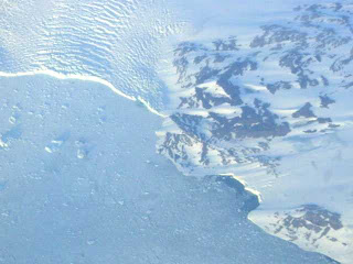
My first selection for this series is an otherwise unremarkable low-resolution shot. It is the back-story that I would like to relate. In 2001, I took my students on our first international field studies trip, to Scotland. It was, in fact, my first interoceanic flight, and I had possessed the digital camera for a grand total of one day, and before taking off, I had taken a grand total of three pictures. The flight, from San Francisco to London, was about 9 hours long. We had individual monitors and a GPS map on our seatbacks, so I knew where we were at all along the flight. The smart folks on the flight knew all about jetlag, and went to sleep. I was very keyed up, couldn't sleep, and I kept my eye on the ground throughout the entire flight (I would regret this 32 hours later when I would finally sleep again). But...the flight path took us over Greenland. I had never seen a continental glacier or ice-cap, and I was anxiously looking forward to my first look. So after 5 hours of waiting, the GPS said we had reached the western coast of Greenland, and of course, there were clouds. And not interesting clouds either. They were featureless stratiform clouds that revealed nothing of the landscape underneath. My frustration was intense. But I waited, and waited. For the next hour or so we flew over the land, seeing nothing. And finally, while everyone else slept, just as we reached the eastern coast, the clouds briefly parted, and for perhaps two minutes, I could see the end of the glacier where it was shedding chunks of ice into the Atlantic. And I snapped this picture. I use it in my classes, even though subsequent flights have revealed much greater scenery.


Thanks for your patience if you made it this far in my story! If you would like to see some of the other pictures of our Scotland journey, check out http://virtual.yosemite.cc.ca.us/ghayes/Scotland.htm.


I look forward to any contributions you might have to offer for this series!