Showing posts with label back of beyond. Show all posts

Sunday, June 22, 2025

Journeys in the Back of Beyond: Starting Off With a Bang


The Granite Mountains adjacent to the Mojave National Preserve

Actually it was a great many bangs. I shall explain...

Let's start with some basic statements. It's the Mojave Desert. It's almost summer. It doesn't rain in deserts, sort of by definition. I plan these excursions to avoid the monsoons of the Desert Southwest. And as the host at our first camp told us, "average June rainfall is 0.01 inches". We'll get back to this interesting meteorological situation shortly...

The first day of our trip was a traveling day, somewhere around 400 miles to get us out of the Central Valley and well into the Mojave Desert so we could reach the Grand Canyon the following day. My marvelous and courageous crew consisted of 17 students and several valued and faithful volunteers who have been making these trips possible for many years. We had a wonderfully diverse group, with some in their late teens, and others in their 60s, 70s, and one incredible traveler well into her 80s. 

All adventures devolve quickly into several basic questions: where is the nearest restroom? Where is the next mini-mart/gas station? How far do we have to camp? Sometimes, to my delight, there is a question about some geological feature visible in the distance: Is that a volcano out there? What's that weird white rock? Our expensive walkie-talkies ($9 each on Amazon) kept us in touch.

We made good time, and even had time to stop and have a look at the vast open pit mine at Boron (source of around half of the world's production of borax minerals). We pulled up to camp about 5 pm and started setting up.

The setting was dramatic. We were tucked in a small draw at the base of the Granite Mountains, which by incredible coincidence are composed almost entirely of granite. This granitic rock has the same origin as the famous granite batholiths of the Sierra Nevada, having been intruded into the continental crust as a result of subduction along the coast of western North America. The sinking slab of oceanic crust heated up and portions of it melted to form the granite magma that forced its way upwards through the crust where it eventually cooled. The subsequent history of the rock was different, however. Where the Sierra Nevada rose as a single massive block of crust sloping to the west, the Mojave twisted and deformed into a series of individual mountain ranges of more moderate elevation.
I guess I should have known what was coming. In my trained scientific experience, if there is a storm anywhere in sight, it will find a way to hit us. Despite the summer temperatures, skies were overcast, and there was a lot of energy in the clouds around us and rain was falling on the distant horizon. Camp was set up and we were preparing our dinner for the night when our phones simultaneously chirped, giving us a flash-flood warning. It was no spurious warning, either. Moments later, the sky opened up with the most intense hailstorm/rainstorm we've ever experienced in 40 years of field studies.


In mere moments the ground was covered with more than an inch of hail, some hailstones as large as quarters (the hood of my Subaru has dozens of small dings on it now). Every small gully and watercourse was filled with flowing water, including our entrance road. And the lightning was constant and terrifying (I didn't grow up in the Midwest, so these intense kinds of thunderstorms are new to me).

What had been dry sere desert moments previous was now coated in a covering of ice. There was enough hail left on the ground the next morning to use in my ice chest. It was a stunning storm.


The next morning as we left for Arizona, we realized we were lucky to be able to leave at all. Our access road had transformed into a river overnight, complete with braided stream channels, and some mud puddles remained that we carefully forced our way through.

Rivers had flowed over Kelbaker Road, but thankfully had not washed out the pavement.

Some nearby roads had been washed out and were closed to traffic, but we were able to reach the main highway and continue our journey east.

How did my students fare in such an incredible storm? 

I should backtrack a bit and explain what happened a few weeks earlier. In past trips we've always stayed at Black Canyon Campground in the Mojave National Preserve. It's a nice spot, and even has a shade structure that could have served as shelter from the downpour when it came. But I was poring over the maps and noticed the Sweeney Granite Mountains Desert Research Center. I remembered touring the place several decades ago, so I looked it up and discovered they had a cabin for use by students and researchers on the north slope of the Granite Mountains. On a whim I asked if they could accommodate our crew, and they were able to do so. 

During the worst of the storm, we were lounging in a nice dining/study area in a cabin!


The Granite Mountains Preserve is administered by the UC System, and covers around 9,000 acres of granite mountain slopes covered by pinon-juniper forests (and an uncomfortable amount of jumping cholla). They do research on all aspects of the desert/mountain ecosystems. There are several different kinds of accommodations for researchers, including the Norris Cabin where we stayed (below). It is a wonderful setting for field work in the desert!
And thus the first 24 hours of our two-week trip was done. The crew had been tested against the single worst storm our program had ever experienced and came out ready for more. Our next destination was the bottom of the Grand Canyon!

Saturday, June 21, 2025

Journeys in the Back of Beyond: Adventures on the Colorado Plateau


Devils Garden in Arches National Park
What is an adventure anymore? 

I ask my students to describe the meaning in one of my offbeat assignments in my geology courses and I get all kinds of answers. Many will describe a experience from our local educational camp in the Sierra Foothills, or an excursion they took to a local river or lake. Many of them have almost never left the city limits, and camping in the Sierra to them is terra incognita, far beyond their experience or expectation. 

I've always known I've had a blessed life in many ways, and what has made it especially rich is the privilege of leading my students on true adventures way out there in America's Back of Beyond, the Colorado Plateau and the Basin and Range country. I've just returned home from one of those journeys.

In Zion National Park

"Back of Beyond" is informally defined by Merriam-Webster as "a place that is very far from other places and people: a remote place". There are literary connections in the writings of Edward Abbey and C.J. Box, and a 1954 documentary from Australia. It is also the name of one of the finest bookstores in Utah. Outside of Alaska, some of the wildest and remote country in the United States is indeed the Colorado Plateau and the Great Basin, and to me it is some of the finest scenery in the world, and its geological story is fascinating. And...the land is endangered.

I'd like you to experience this country, if only through narrative and photography. I hope you will join me over these next few weeks as I describe our experience in a series of blog posts, and perhaps understand why we need to take action to protect the heritage of these fragile lands.

Mesa Arch in Canyonlands National Park

As usual, my ambitions often exceed my time allocation, so forgive me if delays occur in new postings!

Saturday, June 23, 2018

Home From Back of Beyond: Images of a Harsh Country, Part One


Sunset through wildfire smoke at Arches National Park, Utah
If you are familiar with the Chronicles of Narnia, you will remember the novel where the children go through the wardrobe into a magical world and live out their lives to adulthood. At the end of the story they step through the wardrobe back into our world where they are once again children. Little actual time had passed. A journey through alien lands like those of the Colorado Plateau is much the same. One can work and sleep and study and weeks will pass and little will change in one's life. Then, you are ripped away from everyday life and spend two weeks exploring corners of the world that you barely believed existed and each day, each hour is a life-changing experience. More happens in just two weeks than will happen in months or years of an everyday life.
The Rings Trail through Banshee Canyon in the Mojave National Preserve
I've been doing trips like this across the Colorado Plateau for 34 years now, and each one has been unique. There have been new insights and new discoveries every time. Sometimes there have been scary moments, and there have been moments of inspiration and beauty that border on the sacred. Our journey this year was no exception. I got to know twenty unique people, and we shared some interesting times together. I will no doubt have much to say about the geology and natural history of the places we visited in future blogs, but for the moment, I've gone through my 2,300 pictures and selected some of my favorites. It will take several posts!

The Mojave National Preserve is not actually part of the Colorado Plateau, but we needed a place to stay on the way there, and I can't think of a more interesting spot than Hole-in-the-Wall and Banshee Canyon (above). There's a trail that winds through the bizarre canyon with rings placed in strategic spots to allow access. It's not the plateau, but there is a connection: 18.5 million years ago a colossal rhyolite caldera eruption sent ash drifting across a vast region. The same ash exposed on the Rings Trail is also found on parts of the rim of the Grand Canyon near Peach Springs, Arizona.
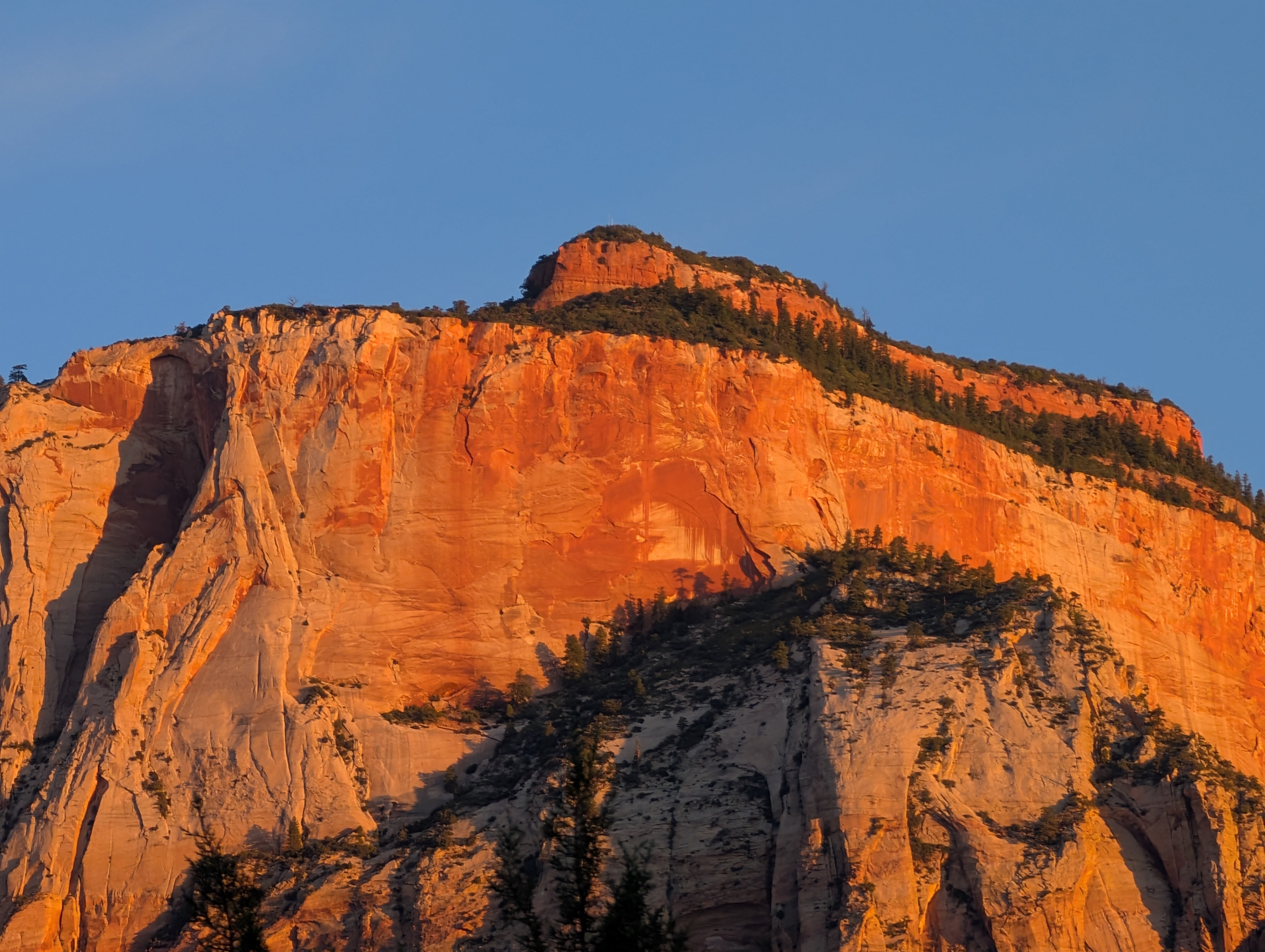
The walls of Zion Canyon from Watchman Campground
We spent a night at Zion National Park which is crowded beyond all reason these days. Too many people want to share a very small space, and the experience of seeing the park is diminished by the crowds. The obvious answer is to make more parklands available, but our government is going the opposite direction, unfortunately. Still there are moments of peace and beauty. The red rock country is always more astounding at the beginning and the ending of each day when the canyon walls are lit by the horizon-level sun. I woke up at 5:45AM to see the sunlight on the canyon wall opposite our camp, and all was quiet. I could have been the only person there at that moment for all I could hear.
 The Transcept Trail follows the rim over the Transcept, a deep tributary to Bright Angel Creek which is itself a tributary tot he Colorado River. In any other place a canyon like this would be its own national park.
Grand Canyon National Park is another place where crowding is rampant and the atmosphere is much like Disneyland. But Grand Canyon is a much larger park, and there are many places where one can find peace. For one thing, a person can visit the North Rim, which gets a mere 10% of park visitation. And once there, walk a little bit. I spent an hour one afternoon walking the Transcept Trail, and saw only three or four people. I snapped the shot above from one of the many overlooks along the way.
The view upstream of Navajo Bridge over the Colorado River
The canyons of the Colorado River are rugged, to say the least (the Grand is just one of them). For decades Lee's Ferry was the only crossing for more than two hundred and fifty miles downstream (and almost as much upstream). In 1928 the Navajo Bridge was completed, allowing auto traffic to make the crossing unimpeded. The bridge was not designed for modern trucks and was augmented in the 1990s with a twin bridge of greater strength. The old bridge is now a walkway, and one can stand 700 feet above the Colorado River just a few miles downstream of the old ferry. California Condors soared overhead while we were there. I chose this picture because of the memories it stirred of my incredible journey down the Colorado in 2013 with my brother's family. The bridge was the last recent piece of human architecture we would see for nine or ten days. I was a tiny bit jealous of the rafters passing below, but I was on an epic journey of my own with a bunch of special people.
Horseshoe Bend on the Colorado River near Page, Arizona
A short distance up the road was another imposing sight, the Horseshoe Bend on the Colorado River. It's just a few miles downstream of Glen Canyon Dam, and was a local secret for a long time. Word is out now and the small dirt parking lot is often overrun with buses and tourists hiking in inappropriate shoes and without hats in the stifling (and dehydration-producing) heat. It is in the process of falling victim to "industrial tourism" as authorities are constructing a parking lot, a concrete pathway, and some fencing at the cliff edge. I guess the "improvements" are necessary, given the stupid chances I saw people taking to get their selfies on the cliff edge.
House on Fire Ruin in Mule Canyon. I photographed the ruin years ago without realizing the presence of the "flames" formed from differential weathering of crossbeds in the sandstone.

My most treasured moment came the next day. We were headed to one of the important cultural sites on the entire Colorado Plateau. A thousand years ago, Cedar Mesa was one of the most critical agricultural landscapes in the entire region, being a thousand feet above the barren deserts of Monument Valley and Mexican Hat, and thousands of feet below the mountains that were coated in snow for much of the winter. It was the sweet spot for growing large yields of beans, squash and maize. For centuries thousands of the Ancestral Pueblo people made the mesa their home, building villages on the mesa top, and cliff dwellings and pithouses in the alcoves just below the rim. They left the region totally in the late 1200s leaving behind thousands of cultural sites that are still only beginning to be assessed and excavated. Five regional tribes consider the lands to be sacred.
Pictographs on sandstone near House on Fire Ruin
The region is public land, managed by the Bureau of Land Management, a chronically underfunded part of the federal government. The archaeological sites have been ravaged by the resident pothunters and grave robbers who live in the region and think that these resources are their own personal cash cow. I read somewhere that around 90% of the known sites have been attacked by pothunters, sometimes using picks and shovels, sometimes with bulldozers. They'll even charter helicopters to fly them into remote sites. With this vandalism in mind, politicians and stakeholders worked for years to propose a national monument, and when Congress failed to act, President Obama made the monument a reality. Bear's Ears National Monument was established in 2016. In an egregious betrayal of the law, the present administration shrunk the monument by 90%. The act is being challenged in court, but mining companies are already staking claims. It's a hideous shame.
Ruins in Mule Canyon
We walked up Mule Canyon listening for the ghosts of those who came before. We found House on Fire ruin, some eerie hand prints on an overhanging rock, and several other incredible ruins (a long way) up the canyon. I walked six miles in the hot sun with not enough water (I don't recommend walking with insufficient amounts of water). It had been around fifteen years since I last traveled up the canyon.
One of my special moments happened as I was waiting for two new tires to be installed after we got a series of flats. Right there in the city limits of Cortez, Colorado there was a little prairie dog town. They ducked every time a car went by.

The picture above needs explanation. That's a cloud, yes, but an unusual one. It's a pyrocumulus cloud, generated by the disastrous La Plata (416) Fire that was burning north of Durango, Colorado. Huge plumes of superheated air rise and cool in the upper atmosphere, condensing to form the gigantic clouds. Unfortunately they don't produce any significant precipitation (wouldn't it be nice if wildfires came with their own extinguishers?). But looking at the drought-induced fire burning beyond the ruins of Mesa Verde caused me to consider the "cycle of life", or more correctly the cycle of human habitation. Many hypotheses concerning the abandonment of the region by the Ancestral Puebloans involve extended droughts and overuse of the available resources. The drought in 1285 AD had lasted around 25 years.

We are currently in another drought that has now lingered for two decades. The Colorado River supplies water for cities and farms across the entire southwest, but the two giant reservoirs that store most of the water are barely half full, and if the drought continues (as predicted by some global warming scenarios), the lakes will become useless pools and cities throughout the region will be in serious trouble as a result. The Ancestral Pueblo people left for wetter climates 700 years ago. What alternatives will the current residents have?

These are my favorite pictures from the first six days of our journey. More will be coming!

Wednesday, June 10, 2015

Headed into the Back of Beyond (Again)

I had hoped to finish our blog journey through the most dangerous plate boundary, but there was just too little time between real-world trips. The next journey is taking me and nearly two dozen students on a trip through time, both geological and anthropological. Our combined geology and archaeology class is exploring the fascinating landscapes of the Ancestral Pueblo people and other groups of the southwestern United States.
Archaeologists learning geology, and geologists learning archaeology. It's a symbiotic educational relationship that enriches students of both disciplines. We've done this trip a number of times, and it seems to get better every time.
This summer equinox picture of Fajada Butte at Chaco Canyon is emblematic of our trip, as we see Cretaceous sedimentary rocks of the Mesa Verde Group making up the cliffs and slopes. In the foreground, a small ruin from the people who lived on this land for more than a thousand years as a distinct culture. They then abandoned the region and 700 years later, a different group of people started to build roads again, with an asphaltic covering material (and mechanical air conditioning in their dwellings).
And all of the students are willing to dabble a bit in biology as well, especially when the object of their attention is so colorful.

Geotripper is going to be hit and miss for the next few weeks. I look forward to sharing our adventures in a few weeks!

Tuesday, June 12, 2012

Heading into Back of Beyond...

Edward Abbey talked about this wilderness as "Back of Beyond". It is the Colorado Plateau, one of the most beautiful landscapes on our planet, and one of the greatest places to learn geology, and in our case, anthropology and archaeology as well. I'm headed there in the morning with 30 geology and anthropology students. We'll be on the road for a bit more than two weeks.
I've been waiting all year for this moment. I have many favorite places in the world, but a huge number of them lie within the boundaries of this province. I'll be seeing some places I know fairly well, and a few places that I've never seen at all. Many of my students on this trip have never been out of California. I love my role as a teacher as they see this place for the first time.
Many awesome sights and wonders. I know that "awesome" has become overused, but the word truly fits in this place. Needless to say, blogging may be hit and miss. I'll try to post pics at the twitter account (@geotripper) and google plus (Garry Hayes) once in awhile too.

Take care, everyone!