Showing posts with label Olympic Peninsula. Show all posts

Wednesday, August 14, 2019

Travels in Cascadia: Traversing the Salish Sea, and Leaving the USA

Morning in Port Angeles, looking across the Salish Sea

It was the third day of our journey through Cascadia, and after our exploration of the Olympic Peninsula, it was now time to leave the United States. We were in Port Angeles, Washington at the north end of the peninsula, and our route to Canada was by way of ferry across the Strait of Juan de Fuca. The landscape was undergoing a dramatic change. First of all we weren't in mountains anymore, we were crossing a sea. That seems an obvious point, but one has to wonder why the mountains abruptly end in a sea, and why similar mountains don't occur across the water. Second, we had reached the southern reach of the vast ice sheets that covered Canada and part of the United States during the Ice Ages that ended only around 12,000 years ago.

These two things, the end of the mountains and the end of the glaciers are related. The Strait we were crossing, along with the Strait of Georgia and the Puget Sound, are collectively known as the Salish Sea. The term was coined in the late 1980s as a way of recognizing the interconnectedness of these bodies of water as a single environmental entity. The name originated with the indigenous people who first colonized the landscape around the sea.
The Salish Sea (from http://blogs.agu.org/fromaglaciersperspective/2015/06/08/salmon-challenges-from-glaciers-to-the-salish-sea/)
The Salish Sea covers about 17,000 square kilometers (6,600 square miles), and has 7,470 kilometers (2,900 miles) of coastline, along with 419 islands. It is a unique ecosystem, a sea in the Pacific Northwest that is somewhat protected from the worst storm violence and wave action out of the Alaska region. Something like 8 million people call the shoreline home, in a megalopolis that extends from West Vancouver to Olympia. Along with people, there are 37 species of sea mammals, 172 species of birds, 247 species of fish, and over 3000 species of invertebrates.

The western margin of the Salish Sea is formed by the Olympic Peninsula and the mountains of Vancouver Island. The Strait of Juan de Fuca slices between the two landmasses. It was the strait that we were traversing on our way to the city of Victoria. 

The Olympic Peninsula is made up mostly of ocean floor sediments and basaltic rock pushed up as material was stuffed into the trench. Vancouver Island has a different origin. It is a piece of continental crust that traveled across the Pacific (at the feverish rate of a few inches per year) only to collide with the western edge of North America. Such far-traveled landmasses are called exotic terranes.

Source: http://www.deq.idaho.gov/regional-offices-issues/coeur-dalene/rathdrum-prairie-aquifer/geologic-history/
The Salish basin was shaped in large part by the ice sheets that covered essentially all of Canada and a good portion of the northern United States. As recently as 12,000 years ago, a mass of ice a mile (1.6 km) thick pushed south through the basin as far as Tacoma. A lobe of ice also extended west through what would become the Strait of Juan de Fuca.

The ferry ride took about 90 minutes to cover the 20 miles of open water between Washington and Vancouver Island. It's a beautiful ride, made all the more interesting as one realizes this entire body of water was once covered by ice. As one gets further out to sea, the higher snow-capped peaks of the Olympic Mountains come into view.

It may be that the water can get pretty choppy, especially during winter storms, but on my four trips across the strait, conditions were very calm. I almost felt like I was on a lake instead of a sea. We were still on dangerous "ground", though. The Strait of Juan de Fuca is not immune to the effects of huge earthquakes, whether in the immediate vicinity (along the Cascadia Subduction Zone), or from those at great distances (such as the 2011 Tohoku earthquake in Japan). The problem, of course, will be tsunamis.

Sometimes confined bodies of water can weaken the effect of tsunamis by dispersing the energy of the waves, but in some circumstances they can magnify the energy instead. There is some evidence of ancient tsunamis along the shorelines of some of the interior islands of the Salish Sea. The effects will probably muted compared to the damage along the Pacific Coast, but more developments are located there as well. On a positive note, the cities in the region are recognizing the threat and are talking action to minimize the damage (see an example here).
It was a beautiful cruise. Soon, we pulled into the harbor at Victoria and got ready to disembark. We were in Canada!

This post is part of a series on our field study of the geology and anthropology of British Columbia and the Pacific Northwest.

Thursday, August 8, 2019

Travels in Cascadia: Threading the Needle on Hurricane Ridge

Leading a field studies trip is a stress-filled enterprise. There are the big things to worry about: auto accidents, injuries, conflicts with law enforcement, lost reservations, and those sorts of things. But those thankfully don't happen much. But weather does happen, and field studies trips tend to be tightly scripted affairs with not much room for weather-related complications. Yet they happen, especially on trips in the Pacific Northwest. We've had trips where we had just the one chance to see Mt. St. Helens, and it was completely fogged in. There was the one chance to see the Sea to Sky Highway in British Columbia, and it was raining the entire way. We've missed a lot.

This year was going to be different. We worked some flexibility into the schedule, spending two nights each at most of our localities, giving us the chance to postpone a particular plan for a day to allow the weather to clear up. But on our second day out, I was worried. Ever since the longest ten-day forecast, a storm was brewing out in the Pacific Ocean, one that was arriving in waves over several days. We had given ourselves two days on the Olympic Peninsula, and rain was falling on Hurricane Ridge the first day, so we elected to go to Neah Bay and Cape Flattery instead. But that left us just one more chance to have a clear view at Hurricane Ridge in Olympic National Park. The sunrise (above) was not promising. According to the forecast, we would have a brief window of maybe three or four hours before the storm closed in, but we drove through light showers on the road up to the ridge.
My concern grew as we continued up the road, rising from sea level to over 5,000 feet. The far ridges would appear for a moment and then become obscured, and I didn't know until we reached the top ridge if we would actually see anything...

… but we did! And no matter how many times I've been on Hurricane Ridge, nothing quite prepares me for the view from the end of the paved road. It is simply astonishing. As we emerged from the vehicles I felt the stress falling away, like dropping a particularly heavy load from my shoulders. We gathered the group and said a few words about the geology. We would save the longer presentations for later in the day down the hill. With an impending storm, I didn't want our students to miss any of the dramatic scenery. And it is dramatic.

The Olympic Mountains rise from sea level to nearly 8,000 feet and are extremely rugged. They capture prodigious amounts of rain and snow on the western flanks, so much so that temperate rainforests coat the western slopes. It was a nightmare for geologists who were trying to unravel the geologic history.

The mountains exist because of subduction. For most of 200 million years a convergent boundary has been active in the region, as the crust of the Pacific Ocean basin has been sinking against the edge of the North American Continent. In some places, like California, the subduction zone has been replaced by a transform boundary (the San Andreas fault). But in Northern California, Oregon, Washington, and part of British Columbia, the subduction zone is still active, still producing earthquakes, and still raising mountains. It's called the Cascadia Subduction Zone (from hence comes the name of this series).
Source: Geological Society of America

In a "normal" subduction zone, there are four parts: the trench, an accretionary wedge, a forearc basin, and a magmatic arc. The trench is the deepest part of the ocean floor where the oceanic crust sinks back into the mantle. The accretionary wedge is a collection of seafloor sediments and crust that has been scraped off the subducting plate and added to the edge of the continent. The forearc basin is a shallow sea that may develop inland of the accretionary wedge (California's Great Valley originated in this fashion). The magmatic arc is a system of volcanoes and intrusive plutons resulting from the melting of rocks in the lower crust and upper mantle above the descending slab (water released from the slab lowers the melting point of the rock, leading to the formation of the molten rock).


Looking at the thickly forested slopes below Hurricane Ridge, I cannot envy the geologists who originally mapped the Olympic Mountains. Simply finding an exposure of rock must have been challenging at times. What these geologists did was to take the rare rock exposures and extrapolate them into a semi-coherent map that reveals the structure of the Olympic Mountains. They did the equivalent of taking a few pieces of a jigsaw puzzle, putting them in the right location relative to the others, and then drawing in the remainder of the puzzle from scratch. I've been way too spoiled by the naked rock exposures of places like Death Valley and the Mojave Desert!

The geologic map reveals the basic structure of the Olympics. A "horseshoe" of basalt and sedimentary rocks (the Peripheral Rocks, or Crescent Formation) partially surrounds the "Core Rocks", an assemblage of lightly metamorphosed sandstone and shale layers. The Core Rocks are characteristic of the types of deposits that form from underwater landslides ("turbidity currents") within the trench and accretionary wedge of a subduction zone. The fact that these rocks are now thousands of feet above sea level is the interesting conundrum. Accretionary wedges are generally below sea level, or exist as small islands. They can be pushed higher. For instance, the rocks of the Cascadia accretionary wedge are exposed in the Coast Ranges of  Washington, Oregon and California, but nowhere are the exposures as spectacular as the Olympic Mountains.


Convergent boundaries can be exceedingly complex places. Bits and pieces of continents and island arcs may randomly arrive at the subduction zone, mucking up the subduction process the way too many sheets of paper at once can muck up a paper-shredder. In the case of the Olympics, there was a mass of land north (Vancouver Island) and an accreted terrane to the south (the North Cascades), and a bend in the subduction zone itself. In essence, too much material was being stuffed into the subduction zone, so the excess material went the only way it could, which was up. The mountains have been rising for around 15 million years. They would be higher, but the incredible amount of precipitation tears the mountains down at a roughly equivalent rate.

Pillow basalt from the subducted oceanic crust is exposed along the Hurricane Ridge Road and along trails near the viewpoint. When we went down the road later on, we found that a small rockfall had dumped some of the pillows onto our highway. So, as it turned out, we managed to miss having rocks fall on our vans, i.e., one of the hazards I mentioned at the start of the post!

We could easily observe the glaciers that scour the upper reaches of the mountains. Glaciers technically shouldn't exist here. Although we were at a high enough latitude, the nearby Pacific Ocean moderates the climate, keeping things warmer than they would otherwise be (the Olympics are at the same latitude as Great Falls, Montana, or St. Paul, Minnesota). But temperature isn't the only factor in glacier development. The sheer amount of snowfall in combination with temperatures that are just cold enough allows glaciers to exist at these unusually low elevations.
We had a good introduction to the basic features of alpine glaciation as we gazed across the valley to Mt. Olympus. There were horns, aretes, and cirques as well. Glaciers were going to be a big part of the story of British Columbia, and Hurricane Ridge provided a spectacular setting for the first discussion of how they worked.
It was nearly noon and the storm clouds were building. We were rained on as we descended back down to the lowlands. It was time to prepare for the ferry ride across the Strait of Juan de Fuca to Vancouver Island.

Travels in Cascadia: How Far Can You Spit? Here's one of the Longest Spits, at Dungeness

I was never a good spitter. We had a hazing ceremony back in the scouting days where we were blindfolded and had a spitting contest. When one of us let loose a big one, everyone started shouting about how far it went, and how it disappeared over the horizon. "It must be going around the world" someone said, and thus we knew we were about to get hit with a pail full of water from the back.

Of course this post isn't about THAT kind of spit. It's something very different. Take a look at the picture above. It's the Dungeness Spit Lighthouse on the Olympic Peninsula in the vicinity of Port Angeles in Washington. If the picture is a little fuzzy, it's because it was taken at extreme zoom. So we'll back up a little. Those snow patches in the distance are on the slopes of Mt. Baker, a stratovolcano of the Cascade Range.
As we pull back even further, one starts to wonder what the lighthouse is built on. Is it an island? Not exactly. If you look carefully to the left you can see a very narrow strip of land. Follow that narrow strip into the next picture...
...and you can see that this narrow strip of land is connected to the coastal bluffs at Dungeness National Wildlife Refuge (yes, the crab is named after the area). It's no more than a hundred or so feet wide.

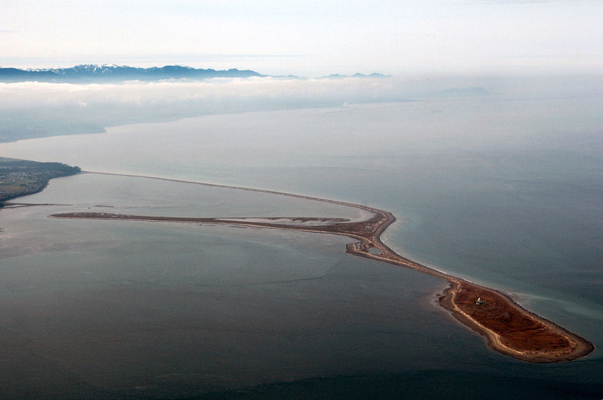
What is this five and a half mile strip of land made of? As it turns out, it's mainly sand and gravel. And that is what a spit is, a long narrow strip of sand connected to a shoreline and extending out into the water. The Dungeness Spit is the longest spit in the United States (Long Beach in southern Washington has the appearance of a spit and is longer, but it is partly composed of solid bedrock beneath the sand and doesn't quite meet the definition).

Sand migrates along shorelines because waves often wash up the beach at an angle but flow straight off the beach. In that way, the sand zig-zags along the beach in a process called longshore transport or beach drift. The movement of sand is continuous, and if the beach sands aren't replenished by river sediments the beaches can become more narrow or disappear entirely (dam building in the last century on most major rivers has led to beach declines across the country's shorelines).
Sometimes there is a sharp turn in the shoreline, or a large bay opening, and turbulent energy is lost as the wave refracts around the turn. The sand is deposited as a bar. The bar grows as more and more sand is added. Bays can be completely blocked by the spit unless rivers provide enough outflow to keep the bar clear. Several of these so-called baymouth bars can be seen in Northern California at Humboldt Lagoons State Park (see some pictures at this link...plus a bonus bad joke).
The Dungeness Spit has an interesting source of sand. During the ice ages more than 13,000 years ago the south end of the continental ice sheet covered this area (it covered the entire Juan de Fuca Strait). The weight of the thick ice pushed the crust of the earth downward hundreds of feet. As the ice age ended, large rivers flowing off the Olympic Mountains built up a large delta of gravel at Dungeness. The gravel was essentially at sea level but the crust rebounded upward forming a coastal terrace several tens of feet high (see the picture below). Waves cut into the terrace, forming the coastal bluffs, and providing a plentiful supply of sand for the Dungeness Spit. At 5.5 miles it continues to grow at around 14-15 feet per year. Heavy storm waves can break through the spit, but sand refills the gap relatively quickly.
The prevailing waves can change direction at times, and so a secondary spit has formed within the coastal side of the Dungeness Spit. It's called the Graveyard Spit, and it can be seen clearly in the Wikipedia picture below. It is fed by sand coming around the end of the Dungeness Spit.

It's not hard to get to the spit. There is a campground and a parking area for the Dungeness National Wildlife Refuge (the enclosed bay is a protected area; more than 200 bird species are known from the area). From the parking lot a half-mile long paved trail wanders through the forest to an overlook where I got most of the pictures seen above. From there you can walk down to the beach and walk as far as you wish out onto the spit. If you are ambitious enough, you can get to the lighthouse for a tour. It dates from 1857 and is the second oldest lighthouse in the state. It is staffed today by volunteers.
Source: Wikipedia


This post is part of a new series about our recent field studies course to British Columbia and Washington. Next stop: Olympic National Park!

Thursday, May 9, 2019

There is Still Time to Join the Geotrippers (but not much)! British Columbia, the Channeled Scablands, the Olympic Peninsula and the North Cascades, June 26-July 10, 2019


What are you going to do this summer? Are there places in the world that you've thought of visiting but never made a plan? Maybe we can be of assistance in fulfilling your dreams! The geology and anthropology departments at Modesto Junior College will be conducting a field course dyad that will explore Washington and British Columbia on June 26-July 10, 2019. Anyone with an interest in geology or anthropology is encouraged to join us (if you want to skip the reading and get to the details, scroll down to the bottom of this post).

Our journey will begin in the Seattle area where we'll get our rental vans (yes, you'll need to find your way to Seattle). We'll then head out to the Olympic Peninsula where we'll explore Olympic National Park (including the iconic view from Hurricane Ridge, above). There will be an opportunity to explore some of the rainforest. Cape Flattery and the Makah Nation will be the anthropology focus on one day.

We'll then take the ferry across the Strait of Georgia to the city of Victoria on Vancouver Island. "Island" barely describes a landmass three hundred miles long. It has been inhabited by humans for thousands of years, and we'll be looking for petroglyphs and other archaeological evidence as we explore the south shore and then work our way north through Duncan to Nanaimo.

From Nanaimo, we'll take a ferry back to the North America mainland at Howe Sound. We will spend several days in the Vancouver area, exploring both the coastal mountains and Fraser River delta, and also the extensive museums in the city.

We'll travel the Sea to the Sky Highway, a spectacular route that leads from Vancouver to Whistler and Pemberton, site of the 2010 Winter Olympics. We'll have a chance to observe active glaciers and potentially active volcanoes, including Mt. Garibaldi and the Black Tusk.
You'll have a chance to figure out how this landscape happened...(below).
 We'll return to the United States by way of the Okanogan Valley and we'll then explore one of the strangest landscapes on Earth, the Grand Coulees and Channeled Scablands. The discovery of evidence for the incredible Spokane Floods of the ice ages is one of the great stories of geology.
We'll wrap up the trip by passing over the Cascade Range at North Cascades National Park with a stop along the potentially active Mt. Baker volcano.

This trip is just the latest of MJC’s unique collaboration of field studies in geology and anthropology, taught by anthropology professor Susan Kerr and geology professor Garry Hayes.

When and How? The group will come together in Renton, Washington (near SeaTac Airport and Seattle) on June 26 and will return to SeaTac mid-day on July 10. We will travel in rental vans, and stay in hotels.

Costs: The trip will cost $1,600, which includes transportation, admission fees, accommodations, and teaching materials. Students will be responsible for getting to and from Seattle, and for meals (many of the hotels offer free breakfasts, and some rooms will have microwaves). There will be the tuition costs for six units of semester credit, and the fees for getting or renewing a passport.

Accommodations: We are staying in a variety of motels and hotels. We are assuming double occupancy for married couples, and double to triple occupancy for singles. We will try to accommodate requests for single rooms for a surcharge, but cannot guarantee it. (The earlier your request, the better the chance for getting extra rooms).

Academics: The field courses are worth three semester units each (total of six). Participants will be expected to keep field notes and to complete worksheets and quizzes during the trip.

Contact the professors for more information (hayesg - at - Yosemite.edu or kerrs - at -Yosemite.edu). 

For up-to-date announcements, check out the trip Facebook page at https://www.facebook.com/groups/1920712791360611/ and the MJC Geology information page at http://hayesg.faculty.mjc.edu/GeologyPacificNorthwest.html


Tuesday, March 12, 2019

Join the Geotrippers! British Columbia, the Channeled Scablands, the Olympic Peninsula and the North Cascades, June 26-July 10, 2019


(This was posted in January, but is re-posted in preparation for a second organizational meeting on March 19)

What are you going to do this summer? Are there places in the world that you've thought of visiting but never made a plan? Maybe we can be of assistance in fulfilling your dreams! The geology and anthropology departments at Modesto Junior College will be conducting a field course dyad that will explore Washington and British Columbia on June 26-July 10, 2019. Anyone with an interest in geology or anthropology is encouraged to join us (if you want to skip the reading and get to the details, scroll down to the bottom of this post).

Our journey will begin in the Seattle area where we'll get our rental vans (yes, you'll need to find your way to Seattle). We'll then head out to the Olympic Peninsula where we'll explore Olympic National Park (including the iconic view from Hurricane Ridge, above). There will be an opportunity to explore some of the rainforest. Cape Flattery and the Makah Nation will be the anthropology focus on one day.

We'll then take the ferry across the Strait of Georgia to the city of Victoria on Vancouver Island. "Island" barely describes a landmass three hundred miles long. It has been inhabited by humans for thousands of years, and we'll be looking for petroglyphs and other archaeological evidence as we explore the south shore and then work our way north through Duncan to Nanaimo.

From Nanaimo, we'll take a ferry back to the North America mainland at Howe Sound. We will spend several days in the Vancouver area, exploring both the coastal mountains and Fraser River delta, and also the extensive museums in the city.

We'll travel the Sea to the Sky Highway, a spectacular route that leads from Vancouver to Whistler and Pemberton, site of the 2010 Winter Olympics. We'll have a chance to observe active glaciers and potentially active volcanoes, including Mt. Garibaldi and the Black Tusk.
You'll have a chance to figure out how this landscape happened...(below).
 We'll return to the United States by way of the Okanogan Valley and we'll then explore one of the strangest landscapes on Earth, the Grand Coulees and Channeled Scablands. The discovery of evidence for the incredible Spokane Floods of the ice ages is one of the great stories of geology.
We'll wrap up the trip by passing over the Cascade Range at North Cascades National Park with a stop along the potentially active Mt. Baker volcano.

This trip is just the latest of MJC’s unique collaboration of field studies in geology and anthropology, taught by anthropology professor Susan Kerr and geology professor Garry Hayes.

When and How? The group will come together in Renton, Washington (near SeaTac Airport and Seattle) on June 26 and will return to SeaTac mid-day on July 10. We will travel in rental vans, and stay in hotels.

Costs: The trip will cost $1,600, which includes transportation, admission fees, accommodations, and teaching materials. Students will be responsible for getting to and from Seattle, and for meals (many of the hotels offer free breakfasts, and some rooms will have microwaves). There will be the tuition costs for six units of semester credit, and the fees for getting or renewing a passport.

Accommodations: We are staying in a variety of motels and hotels. We are assuming double occupancy for married couples, and double to triple occupancy for singles. We will try to accommodate requests for single rooms for a surcharge, but cannot guarantee it. (The earlier your request, the better the chance for getting extra rooms).

Academics: The field courses are worth three semester units each (total of six). Participants will be expected to keep field notes and to complete worksheets and quizzes during the trip.

There will be an informational meeting on Tuesday, March 19 at 5:00 PM in CAT Building 201 on the East Campus of MJC. Contact the professors if you cannot attend (hayesg - at - Yosemite.edu or kerrs - at -Yosemite.edu). If you attended the first organization meeting in January, you don't need to attend the coming meeting.

For up-to-date announcements, check out the trip Facebook page at https://www.facebook.com/groups/1920712791360611/ and the MJC Geology information page at http://hayesg.faculty.mjc.edu/GeologyPacificNorthwest.html