Showing posts with label Joshua Tree. Show all posts

Saturday, April 6, 2019

Tales from the Semi-Super-Bloom Tour, Part 1: The Mojave Desert and El Paso Mountains

A lot of excitement has been generated this year with the plentiful precipitation in the California Desert and the resulting "Super-Bloom". Mrs. Geotripper and I didn't want to totally miss out on the sights, but we didn't want to be in the midst of crowds that we knew would be present in the places in the news like Anza Borrego or Lake Elsinore. So we zeroed in on the part of the California desert that hasn't been in the news: the Owens Valley and Death Valley National Park.
We knew from the start that we might not see a great many flowers because most of the storms had tracked more to the south, but there had still been considerable precipitation, just a bit later than other parts of the desert. So with proper expectations in place, we set out on the road a week ago. The nice thing about low expectations is that you have a good chance to be pleasantly surprised, and we were. It wasn't the 'super-bloom', but it was colorful enough, so we dubbed our journey the "Semi-Super-Bloom Tour".
 The first place that made us pull over was a non-descript road junction on Highway 14 near Jawbone Canyon and the El Paso Mountains in the Mojave Desert. There were lots of small flowers on the desert floor, including Goldfields, Phacelia, Mallows and small Lilies (I welcome and expect corrections on flower identification).
The desert floor where we were traveling has been largely given over to utilitarian uses. In the immediate vicinity there are airports, military bases, and solar arrays, as well as the towns of California City and Mojave. There isn't much wilderness in this part of the desert.
The landscape is geologically interesting, as we were paralleling the Garlock fault, which divides the Mojave Desert from the Sierra Nevada and the Basin and Range Province. The fault is active, with forty miles of left-lateral offset, but it hasn't produced any historical earthquakes of consequence. The potential certainly exists.

Although the fault motion is primarily lateral, some warping and deformation has lifted a mountain range on the north side of the fault, the El Paso Mountains. The mountains are composed largely of older Paleozoic metamorphic rocks. The rocks had been quite deep in the crust, but were brought to the surface and eroded, and by around 12-15 million years ago had been eroded to a fairly flat surface. This surface was eventually covered by terrestrial sediments deposited in alluvial fans, grassy plains and ephemeral lakes that would remind a person of the African savannah. The comparison is apt, because the sediments contain fossils of a diverse fauna that included ancient camels, horses, antelope, elephants, and a number of predators including to the forerunners to our modern cats and canines.
The valley floor where we stopped certainly had flowers, but we could see that a real super-bloom was underway on the slopes of the El Paso Mountains off to the north. The usually dull gray slopes were covered in places with a veritable rainbow of flowers that must have including a great many poppies and lupines.

Our highway turned north, crossed the Garlock fault, and entered Red Rock Canyon State Park, which preserves the Neogene sediments containing the fossils mentioned above. Millions of people have seen Red Rock Canyon, but not necessarily in person. The brightly colored cliffs have been used as the backdrop for hundreds of Hollywood movies (they were the cliffs of 'Snakewater', Montana in the opening scenes of the original Jurassic Park).

We found that many of the Joshua Trees were blooming. The trees are a defining characteristic of the Mojave Desert and are found primarily in east California and portions of Arizona and Nevada. The trees are a potential victim of global warming. Their seeds once were spread in the scat of giant ground sloths during the last ice age, but the sloths are gone, and with the increasing heat, the trees (actually lilies) are unable to propagate up slopes where they can thrive. Ironically, the trees may disappear entirely in the national park that is named after them.
We left Red Rock Canyon and headed north on Highway 395 towards our turnoff to Death Valley at Owens Lake. Along the way we could see that the "foothills" of the Sierra Nevada were also bathed in color. We were headed to Fossil Falls and Red Hill, hoping to see what had changed in the six weeks since we were last there. That will be the subject of our next post...

Thursday, July 4, 2013

Out in America's Never Never: The Mojave, a Vast Unknown Treasure

My students are reading this and saying "We didn't stop here". That's true. But I love the picture and any excuse to show it.

The first morning on the road into America's Never Never found us at Hole in the Wall in the middle of the Mojave National Preserve. The Mojave is a vast region in eastern California that is both well-known, and completely unknown to the residents and visitors to the state. It's "known" because millions of people travel Interstates 15 and 40 every year through the region on their way to Las Vegas or Phoenix. It's "unknown" because the vast majority of travelers never set foot outside their cars except for the bathrooms in Baker or Needles. The landscape between the two interstates is a vast terra incognita to them. It's no wasteland...it is an exceedingly fascinating region, geologically and biologically.
We did wake up to this sight, though. The Providence Mountains, west of Hole in the Wall.

We passed through the heart of the park, traveling from the Essex turnoff on Interstate 40 for 20 miles to the Hole in the Wall campground, and then through the Mid Hills and Mojave Road to Kelso-Cima Road and the Morning Star Mine Road to Interstate 15. Although our time was short, we saw some vast vistas of the third largest unit in the national park system outside of Alaska (I think only Yellowstone National Park and Death Valley National Park are larger; Grand Staircase-Escalante National Monument is also larger, but is administered by the Bureau of Land Management).

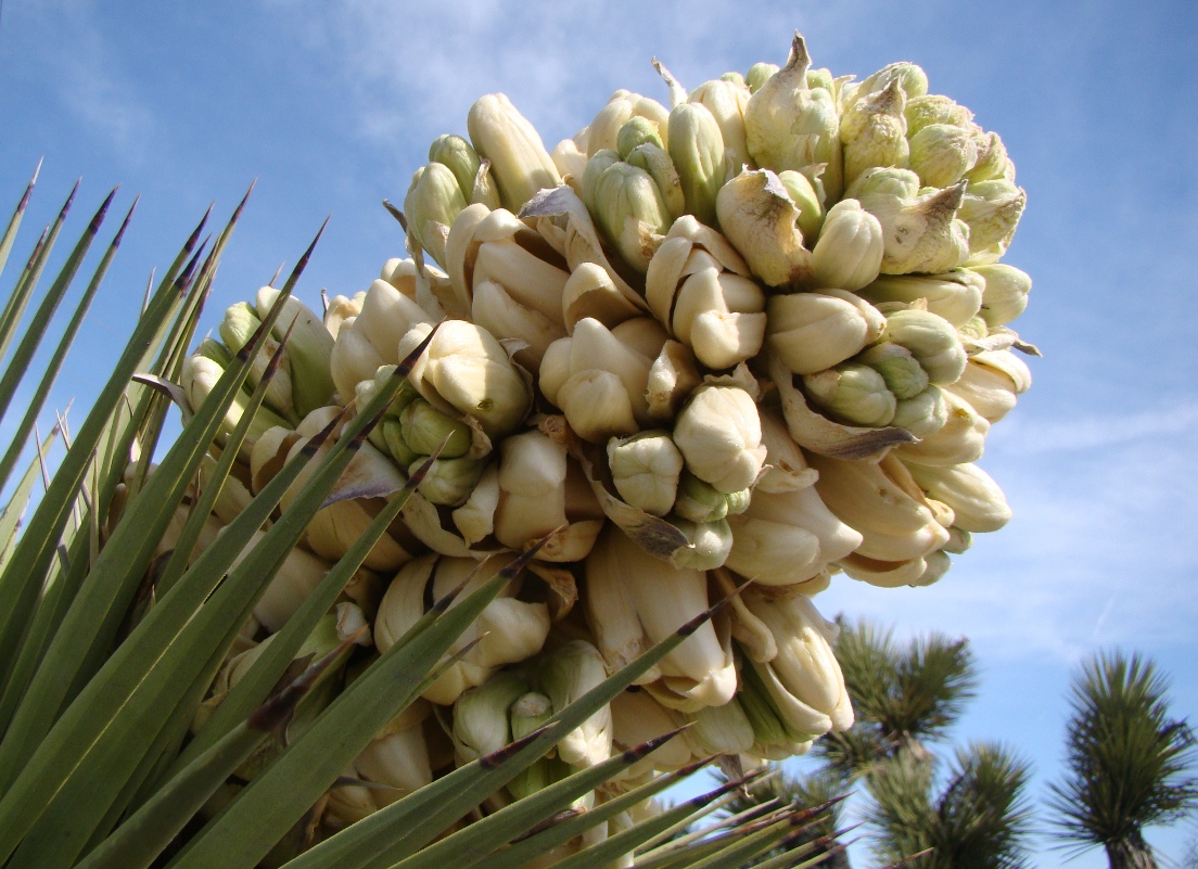
The park has a series of unique ranges, including the Providence, Granite, Clark, and New York Mountains, reacing elevations of just short of 8,000 feet. The great range of elevation allows a huge variety of plants to thrive. Of greatest interest (to me anyway) are the Joshua Trees and the White Firs.

Wait, Christmas trees in the desert? Yes! There are relict forests that cling to life at the tops of the highest peaks of the New York and Clark Mountains. During the ice ages when the climate was wetter, they thrived over a much larger area, but with the ending of the glacial advances and the drying, they retreated to the small groves that exist today. It's a part of the park I have not yet had the privilege to visit, and I can't find pictures on the Internet, so that may be part of a future trip.
Photo by Mrs. Geotripper

The Joshua Trees, on the other hand, are right there. The largest grove in existence, more than a million individual trees, can be seen on Cima Dome. We stopped to have a look. The Joshua Trees are members of the lily family and are widespread throughout the Mojave Desert. Joshua Tree National Park preserves many of the trees, but Mojave National Preserve may actually have more of them. Some of the trees on Cima Dome have trunks 3 feet across, and may be centuries old.
Cima Dome

Cima Dome is one of the more unusual geological structures found in the Mojave Desert. The smooth gravel covered convex surface was thought at one time to be the end result of desert erosion of a faulted mountain block and pediment, but the origin may be more complicated. The Cima Volcanic Field on the west side of the dome may be related. Lava flows range in age from 7 million years to as recently as 10,000 years ago. The top picture of today's post was taken in a lava tube that is part of one of the recent flows.
Photo by Mrs. Geotripper

From our perch high on Cedar Canyon Road, we could look south and see the Kelso Dune Field, one of the highest and largest sand dune systems in the country. The highest dune rises 650 above the surrounding desert. Numerous endemic species of plants grow in the dune environment, but the dunes are best known for "singing". Under the right conditions, the dunes "boom", but the reasons aren't clear.
Kelso Dunes
I have saved my outrage for the last aspect of the park region. Providence Mountains State Recreational Area is an island of state land within the National Preserve. It "preserves" a group of caves, including the Mitchell Caverns and the Cave of the Winding Stair. Originally in private ownership, the state promised to care for the caves and for years conducted tours and kept up the small but charming campground.
Cave shields are a rare cave feature found in Mitchell Caverns (source: National Park Service)
But the recession destroyed the state budget, and the SRA was slated to be shut down. Even when money was found to keep the other parks open, Mitchell Caverns were shut down because the two rangers working there elected to retire. The park was gated and abandoned. The administrators of the park system must have assumed that distance and isolation would protect the facility. Administrators think that way. They were, of course, very wrong.
(source: National Park Service)
Vandals broke into the park visitor center, destroying exhibits, stealing equipment, and removing thousands of feet of copper wire that was used to light the cave. If the park is ever to be reopened, it will cost a great deal more to fix what has been damaged than it would have been to keep a caretaker on site.
(source: National Park Service)
There are hints that the state might be thinking about fixing things now that the state budget is in better shape. I hope they consider bringing back one of the gems of the state park system.

We made our way north out of the Preserve and made our way to the bathrooms and mini-marts over the border in Nevada.

Monday, April 8, 2013

Joshua Trees Blooming Across the Southwest: Is it a problem or just a good year?

During my travels a few weeks back, I noticed a lot of Joshua trees were blooming along Highway 138. We stopped and snapped a few close-ups without giving it much thought. I knew they bloom off and on in different parts of the Mojave Desert. It has come to my attention, via the Press-Enterprise of Riverside, that the Joshua trees are actually blooming everywhere in the Mojave this year. It's unusual, with millions of the trees producing flowers.
According to the article, biologists are not in agreement about what this means. Some seem to think that the bloom is evidence of plentiful soil-water conditions because of extensive late summer-early fall rainstorms.  Others point to two years of overall severe drought, and average temperatures that are 2-3 degrees above average. The trees are reproducing because of stress, a sort of last gasp to produce seed before dying.
Being a geologist, I can't speak to the precise reason for the once-in-a-lifetime bloom, but geologists have provided some perspective about the prospect for the species' survival. Global warming is in fact leading to higher temperatures across the southwest, and the trees must propagate at higher elevations to survive as a species. This has become difficult over the last few thousand years, because there are no longer any grazing animals that can consume the fruits and spread the seed via their droppings.
The last far-ranging animal that did so was the Shasta ground sloth (Nothrotheriops shastensi) , which went extinct across the southwest more than 12,000 years ago. Without the animals to spread the seeds, they can only fall to the ground underneath the parent tree. There are some fears that the Joshua tree will disappear from its namesake National Park in a few generations.
And that would be a real shame. They are beautiful trees.

Wednesday, June 1, 2011

Springtime in the California Desert: Miscellany of Life at Joshua Tree

Wrapping up a week of posts on Joshua Tree National Park, I am offering up a miscellany of life at the unique park in Southern California. A visit in the middle of May is a bit past the height of spring bloom, but there were a few flowers left to enjoy, no doubt assisted by the cool spring. It certainly didn't feel like summer out there.

One of the most dramatic flowers we saw was the ocotillo, a Colorado Desert species that lives in the lower elevations of the park. The ocotillos near Cottonwood Springs were bright with color.
One of the oddest corners of the park is the Cholla Garden at the western end of the Pinto Basin. Chollas are one of the most viciously defended plants one will ever come across. The thorns of the plant are hooked in such a way that if you brush against it, the branch will break off and stick to your skin, by the painful thorns. When you try to brush it off, the thorns stick to your hand. A comb is a vital piece of hiking equipment when hiking in cholla country.

The tendency to break off, besides leading to the "jumping" legend, is also an efficient way of propagating the species. The broken branches can sprout when they get dropped off at a new location.

In most places of the lower desert of Joshua Tree the chollas are widely dispersed, but at Cholla Garden, the chollas are growing in a nearly pure stand, probably due to perfect soil conditions.
Despite the nasty reputation, the Jumping Cholla has a beautiful flower, as can be seen below.
There were a lot of diminutive flowers to be found across the desert, one of which I didn't have any resources to identify. Any help out there?
No problem identifying this one, though. The beavertail cactus is found all over, and the blooms are distinctive...
The rich vegetation was bringing out all manner of insects and birds and reptiles. At the south entrance of the park, I caught one I've never noticed before. It turns out to be a gnatcatcher, perhaps the Blacktailed or California species.
The presence of flowers meant rich time for the hummingbirds, not a species I usually associate with the desert. I saw this one near the Barker Dam trailhead.
There are the usual reptiles. This lizard was well-camouflaged at the base of a fan palm at Cottonwood Springs. I'm assuming a Western Fence Lizard, but will appreciate corrections.
Finally, a mystery beast from the desert. I saw this...something or another...walking across the desert in the Pinto Basin. I thought some kind of wasp from the size, but I haven't a clue what it really is or what that...thing...is on its back. Anyone want to pitch in here?

Monday, May 30, 2011

What's Eating the Joshua Trees? What's Not Eating Them?

For some reason, the powers-that-be somehow failed to call the incredible geological desert in Southern California "Great Big Granite Boulders National Park". They called it "Joshua Tree National Park" instead. I don't quite understand, but that's the way things go sometimes. Really though, the bizarre little 'trees' have a geological history, and it may be their undoing.
The Joshua Tree is actually a member of the yucca family (Yucca brevifolia, meaning short-leaved yucca), and is so closely associated with the Mohave Desert that the boundaries of the one practically coincide with the other. The "trees" grow to a height of 35-40 feet, and are a centerpiece of the Mojave ecosystem, as many animals shelter within the tree and underneath it. The trees have a symbiotic relationship with the Yucca Moth, in which the moth is pretty much the only organism that pollenizes the flowers, and the larvae of the moth pretty much eat only the seeds of the Joshua Tree.
The iconic trees of Joshua Tree National Park are threatened, and as is often the case, we have met the enemy, and he is us. Human generated global warming is raising temperatures in the California Desert, just as it is everywhere else. Joshua Trees are sensitive to such climate change and are no longer propagating in the hotter areas of the park. As the climate warms, more and more trees in the lower edges of the desert will disappear. Normally they would propagate in higher cooler parts of the park, but there is a complication...the problem is a load of crap, or more properly a bunch of dung that is no longer being made.
Today, the only animal that transports Joshua Tree seeds is the woodrat, but they don't move much more than a 100-150 feet from the trees. That's not far enough to get the seeds to higher, cooler elevations, and so there is a possibility that within 50-100 years, most of the Joshua Trees will be gone from Joshua Tree National Park, just as the glaciers will be gone from Glacier National Park. There will be places at the north edge of their range where they will be able to survive, but they may have trouble getting there without human assistance.

So how did the trees get around in the past? That's where the dung comes in (or out...). It seems that we have discovered the droppings of giant ground sloths which once lived all across the southwest. It seems odd that we would have examples of their, uh, reprocessed food, but some of them favored dry caves and there are lots of samples to work with. And they contain a lot of Joshua Tree seeds and leaves. It is pretty clear that sloths provided mobility to the seeds of the Joshua Tree, and when they went extinct 12,000-13,000 years ago, the range of the Joshua Tree began to decline during the climate disturbances in subsequent Holocene time.
The picture above is a Harlan's Ground Sloth on exhibit at the Fossil Discovery Center near Madera in Central California. Despite the ferocious looking claws, it was probably a rather peaceful creature. I just hate that we cannot witness the wonderful menagerie of creatures that lived in North America just a few thousand years ago, although a few were probably the stuff of human nightmares (a future blog on this will be forthcoming). It occurs to me that instead of having humans simply plant Joshua Trees to insure their survival, we should be following a more logical solution. Doesn't it make more sense to use the DNA of the sloths to reproduce new sloths a la "Jurassic Park", and then release them into the wild to do the work that they were meant to do? How hard could it be, really?

For more info on the Joshua Tree and climate change problem check out this NPR story.

Saturday, December 25, 2010

The Last Christmas Gift: A Joshua Tree

A last Christmas scene...

Some of my family lives in the desert near Joshua Tree National Park. We hadn't been there in the past, and expected one of those California-style cookie cutter housing developments imposed on a desert landscape that doesn't really reflect the nature of the desert. Arriving late in the day, I was delighted to find that there was an unspoiled Joshua Tree forest adjacent to their lot. The sun was setting, so I took off across the desert to get a few pictures.

Joshua Trees are a species almost unique to California (I think a few spill over into Arizona and Nevada), and they are a semi-tropical holdover from a different climate and ecosystem. Their seeds do not have a readily available method of dispersal so the tree isn't invading new habitats as the climate grows warmer. It has been suggested that prior to 13,000 years before the present their seeds were spread by giant ground sloths, who were known to eat the fruits of the tree. No animal performs the task today.
The tree got its name from the early Mormon colonizers in the region, who likened the branches to the arms of Joshua of the Bible raised in prayer. They are a unique part of the flora that defines the Mojave Desert.

Have a good Christmas night!

Tuesday, February 16, 2010

A Global Warming Bucket List...

I am writing this blog post today in penance for my faux pas the other day in describing the "climate" at Death Valley as "unusually wet" this week. It was the weather that was wet, not the climate. It was a sophomoric mistake, made worse in my mind because of the cacophony of idiots who decided that global warming and climate change are myths because it snowed in Washington D.C. last week. Changes due to global warming are happening all around us. To deny it, like many conservative politicians and talking heads are doing, is comparable to saying the Titanic isn't sinking as the water laps around one's ankles.

Over at High Country News, "Writer on the Range" Tim Lydon offers up a bucket list of those places to see, not before we die, but before they disappear due to the effects of global warming and climate change. He concentrated on Alaska, ground zero for the effects of warming climate, and areas like Yellowstone and Glacier National Parks in the lower 48 states. It brought to mind some places I need to see soon.

Lydon notes the glaciers in Glacier National Park may disappear in as little as a decade, but California has her glaciers too, including the Palisades Glaciers, seen above in a view from the White Mountains across the Owens Valley. The glaciers of the Sierra have lost something like 75% of their volume over the last century. They won't be around long, and I've only hiked up to one of them.

Another part of our heritage that may disappear is the relic forests of the Mojave. During the ice ages, forests of conifers extended across the Mojave Desert and Basin and Range Provinces. Adapted to wetter conditions, the species retreated as the region became a desert, and most of the forests disappeared until a few small islands remained. These include small white fir forests at the summit of Kingston Peak and the Clark Range. I've never seen them up close.

The Joshua Trees are losing ground as well. They will probably be present for many centuries after I am gone, but their range is decreasing as the climate warms. Their seeds used to be spread in the dung of ground sloths, but without the sloths which went extinct 11,000 years ago, they can't propagate to higher cooler mountain ranges as effectively as conditions continue to warm up.
I've watched with dismay as the forests of my youthful adventures in Southern California have burned up in massive wildfires. The giant 270 square mile fire in Angeles National Forest last year hit me especially hard. Wildfires have always been a fact of life in SoCal. Whether the increasing intensity and extent of the wildfires results from warming or from management issues, the forests will probably be replaced with species characteristic of a drier environment. My favorite Jeffrey Pine forests on Mt. Baldy and in Holcomb Valley may become a thing of the past.

What's changing in your region?

Saturday, December 20, 2008

Christmas Greetings from the Mojave Desert!

Not an unknown sight, but rare enough that I have only seen it a few times despite living my early life near by: snow in the western Mojave. Caught the picture going 65 mph on the way to Arizona for some Christmas visits. The desert between Mojave and Barstow is composed of granite and metamorphic bedrock, with occasional exposures of volcanic rock, but mostly the landscape is gentle hills and wide alluvium-filled valleys. And pretty when the snow falls.

The unusual looking plant is a Joshua tree, so named because the early Mormon settlers in the region recalled Joshua holding his arms towards the heavens. It is a member of the lily family. I have run across recent studies that suggest that the range of the tree is declining because the seeds were once dispersed in part by ground sloths, which went extinct in this region at the end of the ice ages.