Showing posts with label Coyote. Show all posts

Monday, April 2, 2018

A Shaggy Sheepdog Story for an April Fool's Sunday

This was just a little fun I had today, although I had a moment of worry, wondering about the wrath of a wary guard dog. We've visited the San Luis National Wildlife Refuge several times in the last few weeks. The refuges seek to maintain an environment conducive to the survival of the native birds and other animals of the Central Valley. Unfortunately over the years, many of the native species have disappeared or have been displaced. This is especially true of the big grazers. The valley once hosted mammoths, mastodons, bison, horses, camels, and pronghorns.
So the rebuilding of the natural grasslands involves returning native species of grass, and to the extent possible, the return of larger grazing animals. The managers will often allow the limited grazing of the prairie by domestic sheep and cattle. We've been seeing a herd of sheep on our recent visits. We haven't seen the human shepherds, but we've noticed the herd's protectors: some rather large sheep dogs. I think they are a breed called Maremma or Great Pyrenees.
And the sheep do need protection. Their natural defensive nature has been largely bred out, and they don't really know how to face down predators like the coyotes we've seen in the vicinity of the sheep herds.

So, we were there again today, enjoying the beautiful spring weather and the birds, and even a few newly born lambs in the sheep herd. We got to the southeast corner of the Waterfowl Auto-tour, and found out that the sheep dogs recognized us as a possible threat to the sheep. They actually jumped a fence, slogged through an irrigation canal, and loudly barking and growling, chased our car down the road to the Souza Marsh. They finally seemed to lose interest and fell behind. We parked and I walked around for a few minutes. Then I turned to walk back to the car...and came face to face with a very large sheep dog! Those crafty little beasts had snuck up on us and had me trapped in the open.
I actually got bit by a panicked dog a couple of weeks ago, so I was painfully aware of what a dog bite can feel like. I was more than just a little nervous. Luckily, Mrs. Geotripper was already in the car, but I was frozen in place. I finally realized they weren't barking, just watching. I walked slowly to the car. The dogs allowed me to get in the car without making a sound. And then: they herded us out of the marsh and away from the sheep flock, with one dog on either side of the rear of the car. Not a growl or a bark between them. They walked us almost a quarter mile in a highly disciplined manner.

I fear for the well-being of the coyote who decides to go up against them.

So, there you go for an April Fool's Day, a shaggy dog story, but without the painfully stupid pun at the end. At least none that I could think of in the spur of the moment.

Monday, March 19, 2018

Mrs. Geotripper Faces Down the Wolf: Musings on the Canids of the Great Valley

Note: I know this is a coyote, not a wolf. But read on to see why I used the term
They've always been here.

They've always been here, even though we declared war on them, and have tried to exterminate them out of existence. No doubt they're been preying on our chickens, our sheep, our calves, or whatever, but they were here first and we were the interlopers, the invasive species. We came and plowed under the prairies and river floodplains that were the ancestral homes of these creatures.
Photo by Mrs. Geotripper
They've been here ever since the prairie rose from the sea sometime in the last 10 million years. At that time, volcanoes still erupted at the crest of the Sierra Nevada, sending lava flows and volcanic mudflows (lahars) down the western slope. The rock layers today are called the Mehrten Formation, and those rocks are the focus of a study published this week by among others, my colleague at CSU Stanislaus Julia Sankey, and a former student of mine, Jake Biewer. They were looking at the fossil canids reported from the Mehrten, and their work shows that the ecosystem at that time included at least four dog ancestors. There were two borophages (a primitive "bone-crushing dog" that is now extinct), an ancestral fox, and Eucyon davisi, a canid that is considered to be an ancestor of today's coyote.

During the ice ages, the ecosystem was dominated by Dire Wolves and Sabertooth Cats, but fossil discoveries show that the coyote was present as well 700,000 years ago. The big wolves and sabertooths could attack and take down the large grazing animals of the time, the camels, horses, and bison, but there was always a place in ecosystem for the smaller predators that could live on rabbits, rodents, and large birds.

At the end of the last ice age (or with the arrival of humans; there is a debate), the megafauna, the large grazing animals like the bison, the mammoth, the camel, the horse, and the sloth went extinct. Deprived of their prey, the large cats and Dire Wolves also disappeared into oblivion. But there was always a place for the coyote, and they prospered in the newly changed world. As humans moved into their environment, they adapted, and have continued to survive despite the war against them waged by ranchers.

So this thing happened today. Mrs. Geotripper and I were doing something we love, exploring the local wildlife refuge (the San Luis National Wildlife Refuge Waterfowl Auto-tour). We were looking for birds as we usually do, but I had just seen the article about the canids, and so I was also watching the prairie for coyotes (or foxes, I wasn't being choosy). And we saw one! It was wandering the grassland, and stayed close enough that we got pictures and video (below). We drove on. Towards the end of the auto-tour there is a hiking trail to a viewing platform. We got out and walked the trail.

Mrs. Geotripper and I have opposing methods of seeking birds. I like to cover as much ground as possible, constantly moving, while she prefers to remain stationary, letting the birds come to her. Both strategies work for us, and we usually get a different set of bird discoveries. So it was that she was situated on a folding chair at a bend in the trail, and I was a quarter mile away at the viewing platform. We were sort of nonplussed at a sign at the trailhead warning of Mountain Lion sightings, but we had phones so we could stay in touch.

I was up on the platform and was startled, yet pleased to see a coyote go loping by at a fast pace. I'm not even sure it saw me, because it never looked my direction. I snapped some pictures, including the ones above and below, as well as the opening picture at the top of the post. I paused and realized the animal was headed down the road towards Mrs. Geotripper's viewing spot, so I figured I would text her a warning. It read (and I quote): "Coyote might be running your way".

She didn't get the text.

The coyote was faster than my fingers and the mysterious ether of the internet, and so from Mrs. Geotripper's point of view things were a little different. She was photographing a Spotted Towhee, (and thinking just a little bit about mountain lions), when she heard something running through the underbrush. She thought "rabbit", but realized it was bigger. Much bigger. And it was coming closer and closer, and she couldn't see it.

Meanwhile, the coyote was taking a shortcut, probably one that it always took, and wasn't really on the hunt, so it wasn't trying to be stealthy. It was just in a hurry to get to wherever it was going, and it ran into the clearing that it always ran into. And found a large creature in the way.

Both of them were too shocked to react for several seconds, but to Mrs. Geotripper's credit, she didn't scream or panic. She just stared, uncertain what the heck to do next. Luckily, the coyote blinked first and ran down the road as fast as it could go. And then Mrs. Geotripper heard her phone ping with the message I had just sent.

She and I had just encountered a bit of the ancient world that existed long before we did. The wolves and coyotes (and domestic dogs) are closely related creatures, and are even capable of interbreeding. That gives them an incredible advantage in a changing environment, whether rapid climate change like the ending of an ice age, or the invasion of their lands by a new species that is as intelligent and crafty as they are. They can adapt quickly, and that's how they have survived for millions of years against many challenges.

Reference: Balisi, M., X. Wang, J. Sankey, J. Biewer, and D. Garber. 2018. Fossil canids from the Mehrten Formation, Late Cenozoic of Northern California. Journal of Vertebrate Paleontology. DOI: 10.1080/02724634.2017.1405009.

Saturday, February 27, 2016

Cartoons Come to Life: The Value of Field Studies at Red Rock Canyon


I spend a lot of time in classrooms drawing cartoons. Lots of them, diagrammatically representing folds, faults and stratigraphy, trying to communicate to my students how these structures tell the story of the Earth. The problem for many of my students is that these are just cartoons. Cartoons on Saturday mornings (do ANY of you remember when that was the only time one got to watch cartoons?) do represent life in a way, but only if you have a real life to compare them to. And that's the problem for many students these days. They have no real-life experiences in the outdoors with which to compare these drawings.

And thus, the value of a field studies course. There is nothing quite like having the privilege of standing beneath a cliff, enjoying and appreciating the scenery, yes, but also being able to understand the story it tells. Our trip to Death Valley a few weeks ago included a fossil hunt at the first stop, but our second was a site where basic principles of geology stand out in stark relief, without a need for a chalkboard cartoon (I forgot the chalkboard this trip anyway). We had arrived at Red Rock Canyon State Park in the Mojave Desert. Just stepping out of the vehicles presented us a cliff face that was a physical representation of the diagram at the top of the post, a series of brightly colored layers of sand, siltstone and volcanic tuff transected by a fault.

The order of the layering provides a fine example of "superposition", the principle that layered rocks are stacked oldest to youngest, unless they have been overturned. This is one of the earliest principles of geology, described originally by Nicolas Steno in the 1600s. Looking east along the cliff we could also see the physical manifestation of another Steno principle, that of original horizontality. Most sedimentary environments produce horizontal strata (think floodplains or lakes, or shallow seas). If layers are tilted, some kind of force has acted on them, and being here in southern California, faults might be at fault.

A discussion of these basic principles was followed by a short "mapping" project. We weren't quite to the proficiency of working with maps, but the students set out to propose how they would organize the layers into formations and members that could be used to tell a logical story as to how these rocks could have come to have the structure and appearance they have today.

Red Rock Canyon does have a fascinating story as it turns out. The red and brown layers, called the Dove Springs Formation, record deposition of silt and sand in river floodplains and ephemeral lakes between 12.5 to 7.5 million years ago. The semiarid savanna environment supported a diverse ecosystem that included extinct elephants (gomphotherium), ancestral rhinos, three-toed horses, giraffe-like camels, saber-toothed cats, and bone-crushing ancestors to the bears and dogs. There are also numerous smaller fossils like ancestral skunks, alligator lizards, and shrews, with a total plant and animal species count of more than one hundred. The ecosystem suffered the occasional catastrophe as it was buried by volcanic ash. Basaltic lava flowed across the region.
One of the student's discoveries was a somewhat less visible fault that shifted the layers. It was a great introduction into the mind of field geologists, seeing the world the way earth scientists do. It was an interesting spot, but there were many more to come on the road ahead.

Speaking of roads and cartoons come to life...here's the Roadrunner (pic is actually from Joshua Tree National Park)....

...and Wiley E. Coyote. Despite living in the most desolate driest place in North America, it looks like this one has actually caught a few roadrunners! Seriously, this coyote lives only a few miles from Badwater, the hottest and lowest part of Death Valley.

Saturday, January 17, 2015

The Way it Was This Week: Winter in the Valley of the Ah-wah-nee


Is there a more beautiful place than this, the Ah-wah-nee, or the Yosemite as some chose to call it years ago? I'm sure that everyone who explores the outdoors has "that place", the spot that represents the highest attainment of their personal concept of beauty in nature. In my life so far, there is no place more beautiful than this.


It isn't just the scenery, which of course is spectacular. It the privilege of coming back time after time, seeing the valley and park in all seasons and all conditions. I've driven through snowstorms, rainstorms, floods, and heatwaves to reach the valley, during every month of the year. I'm guessing I've made the journey 80 or 90 times in the quarter century that I've lived in the adjacent San Joaquin Valley. I've never had a disappointing trip. There is always something new, and there are the old familiar places as well. And much more remains to be explored.
As is clear from the last couple of posts, I was in Yosemite again over the weekend, a sort of last hurrah before beginning the new semester. Despite the lack of snow in the dead of winter, it was a serenely beautiful place. And...very uncrowded. There was some kind of big athletic competition taking place last Sunday or something. The Sentinel Bridge parking area is usually packed with vehicles. Here's how it was on Sunday:

It's a rarely fulfilled desire, the dream to have the most beautiful place in the world to myself. It's just a little selfish too, but hey, I wasn't keeping anyone else from visiting that day. Most seasons it is quite hard to imagine Yosemite Valley as a wilderness. It hasn't been a wilderness for nearly two centuries. But on Sunday, here and there, it was possible to envision the wildness.

After a long dry spell, Yosemite Falls began to flow again a few weeks ago after our December storms. I hope we will have some more storms soon. After a record-setting December, January has been dry. How dry? Zilch, not a drop of rain in the San Joaquin Valley, and none in the 10 day forecast. It is a bit worrisome. Three years of record-setting drought, and this year has the makings of a fourth.

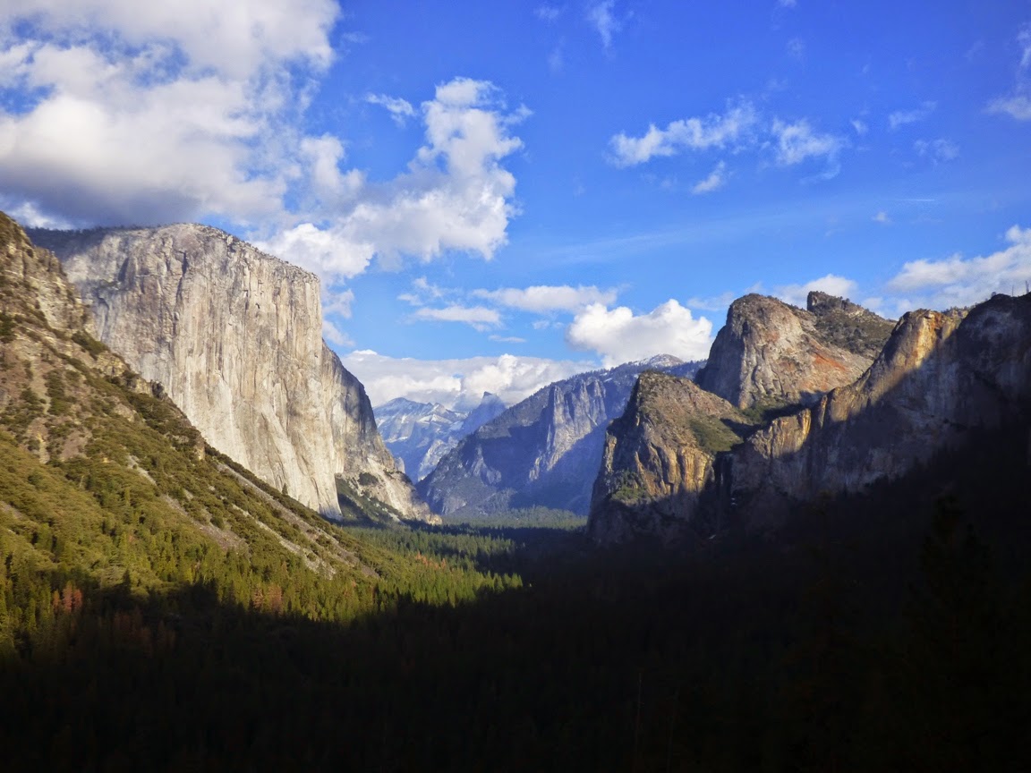
We don't usually stop at the Swinging Bridge Picnic Area, as it is usually packed with people, but not Sunday. It offered wonderful views of Upper Yosemite Falls, and one of Yosemite's less familiar peaks, North Dome (above). I'm pretty sure that if Half Dome didn't exist, or Yosemite Falls, or El Capitan, or Sentinel Rock, or Cathedral Rocks, well then, I am sure that North Dome would be one of the most famous landmarks in Yosemite Valley.
Late in the day we found ourselves in the meadow below El Capitan looking for the free-climbers as they worked their way up the cliff. The few people who were still there were looking up so intently that it took a few moments for anyone to notice that a coyote was standing among us.

I took a moment to look at the oft-ignored cliff across from El Capitan, the wall of spires between Cathedral Rocks and Sentinel Rock. The names are less familiar to most park visitors, Crocker Point, Stanford Point, Taft Fissures, and again, in any other setting, these peaks and cliffs would be the focus of a national park, rather than the relatively unknown cliffs that they are. If the panorama shot below seems a bit less sharp, it's because it was done with my smart phone rather than my usual camera.
It was a beautiful day in a beautiful place. I'm anxious to return.

Where is your most beautiful place?

Sunday, November 2, 2014

The Way it Was Today: Fall (and a bit of Winter) in Yosemite Valley


It always comes back to Yosemite. I travel many places, explore many mountains, see the most incredible geology, but the circle of my life always involves a valley of granite in the Sierra Nevada. I was thinking about why this afternoon during a bit of free time while my students were on a project. I was walking from Yosemite Lodge to Happy Isles, a stroll of three miles or so, and I realized it was this: there are the memorable spots you will visit once or twice in a lifetime to be impressed by, and there are those special places that by circumstance you are allowed to return to time and time again. I live just a two hour drive from Yosemite National Park. I'm guessing I've been there at least 80 times in the last quarter century. I've explored it in every season of the year, in wet years and dry, recently burned and recently flooded. And every time there is something new.

Today I was walking across Cook Meadow near Sentinel Bridge when I heard someone pad up behind me on the boardwalk and then jump off into the meadow. I was about to tell them to stay off the meadow grass when I realized it wasn't a person, it was a coyote, and I was in its way. It trotted around me and back onto the boardwalk and into the forest. We were going the same way so I followed for awhile until it passed some fawns, a doe, and buck in the forest. They ignored me too
The fall colors were stunning (yes easterners, I know that word should only be reserved for New England and such places, but in California any bright colors impress). The Merced River was at the seasonal low point and the surface of the river was a mirror.
We had arrived literally on the heels of the first major storm of the year which overnight had dropped an inch or more of rain in the valley and a foot of snow in the high country. It was still drizzling and the clouds obscured the cliffs, so my attention was mostly on things close at hand.
It wasn't much, but the rain rejuvenated Yosemite Falls for the first time in many months. A trickle is barely visible in the picture above.
The Oaks and Dogwood trees added a splash of yellow, orange and pink to the scenery.
Cottonwood, birch and aspen were also turning.
The clouds started to lift and move on, revealing ghostly cliffs and stony ramparts up above. Sentinel Rock appeared first (above). Snow clung to every tree branch in the forest above.
Finally the skies started to clear over the monarch of the upper valley, Half Dome.
Closer at hand a Raven was watching for any dropped tidbits from the students who were waiting for the tram.
We stopped near Yosemite Falls to talk about hanging valleys, but Half Dome still captured most of the attention. It gains new depth when wreathed in clouds.
We had skipped Tunnel View at the beginning of the day because nothing would have been visible. The situation was different in the late afternoon. We headed up for a look, and it was nothing short of spectacular. I've got only a few (okay, many) hundreds of pictures from this spot and it is never the same. Today was special.
The last rays of the sun were vanishing as we left the valley for home.
And that's the way it was today in Yosemite, my special place. Come and see it when you can!

Saturday, March 9, 2013

A Bald Eagle, a Raven, and a Turkey Vulture Were Having Lunch Together...No, Really!


To my birding readers: how is this for an odd scene? It's the strangest bird picture I've ever taken, and the first ever of a bald eagle. I imagine they've been in our area for awhile, but until today I had never seen one south of Lake Tahoe. We were driving up through the Sierra Nevada foothills between the Gold Rush towns of Hornitos and Mariposa, and came across the group of scavenging birds. Mrs. Geotripper saw a pair of eagles in the Don Pedro Reservoir area two weeks ago, so I am wondering if they have moved into the region permanently.

I am also wondering if the coyote was shot (I certainly hope not poisoned) since I'm guessing that coyotes are too big to be attacked by the eagles. The scene was playing out in a large pasture allotment along Hornitos Road at an elevation of about 1,100 feet.

Saturday, December 8, 2012

It's a Dog's World...and Ours, Too

A coyote in Yosemite National Park
This is a story of the evolutionary journey from the first furry things to Fifi the toy poodle...the story of the dog clan on Earth and how a group of sometimes vicious carnivores turned into one of the closest companions to humans on the planet (don't get me wrong; I love cats and horses too). This will be a two-parter for reasons that will become clear. I don't know whether to call the ending happy or sad, because I am still in the middle of it.

To anyone with smattering of knowledge of things biological, the idea that predators are going to exist in any complex ecosystem is absolutely logical. Since Cambrian time 545 million years ago, and probably earlier, there have been organisms that cannot make food for themselves through photosynthesis, and must survive by consuming carbohydrates that have been produced by other creatures and organisms. Early on there were bizarre creatures like the anomalocaris that swam about munching on the trilobites and other early Paleozoic sea creatures. Fish ate each other, sharks ate anything that moved, amphibians and early reptiles chased and consumed each other, and in the Mesozoic era, evolution provided land ecosystems with some of the most terrifying meat-eaters of all time: the tyrannosaurs and the raptors (always good fodder for the Jurassic Park franchise).

When creatures like the Velociraptor and Deinonychus were munching on plant-eaters like Tenontosaurus and Zephyrosaurus, small furry creatures were running about the underbrush trying hard not to get stepped on or eaten by the larger dinosaurs. They were more likely than not to be active at night. The mammals arrived on the scene not too long after the dinosaurs, but did not become a dominant part of terrestrial ecosystems until a giant rock from space took out their larger competitors (or whatever it was that did in the dinosaurs). Even with the dinosaurs gone, mammals still had to contend with their offshoots, the birds. Some early Cenozoic birds grew to such large proportions that I can imagine their mammal contemporaries rolling their eyes and thinking "not again".
The only wild wolf I've ever seen. Taken in Yellowstone National Park
There were some early Cenozoic predators called creodonts, and others known  as mesonychids who eventually overcame the birds in competition for the top spots in the food chain. From 55 million to 35 million years ago, they pretty much did what they wanted to in regards to procuring food. Smaller weasel-like predators also thrived, and from these smaller creatures, the carnivorans evolved.

During Eocene time, around 40 million years ago, the carnivores diverged into the two main clades that we recognize today: the Caniformia (dogs, bears, weasels, skunks, raccoons and pinnipeds), and the Feliformia (cats, hyenas, civets, and mongooses). Members of an early Caniformia family, the Amphicyonidae, are often informally referred to as "bear-dogs" in the sense that they were probably ancestral to both groups.
Death Valley coyote
Evolution is a matter of isolation and divergence, and so it was that wolf and fox ancestors diverged around 5-10 million years ago, and coyotes and wolves diverged less than two million years ago. They are close relatives. But not as close as the domestic dogs and wolves. Dogs are wolves in the sense that their DNA is essentially identical. They are the wolves that were domesticated and bred for desirable characteristics, starting around 15,000-30,000 years ago. The intense relationship between humans and dogs had begun.

Biologists debate about how domestication took place. Some say that humans raised wolf pups, and eventually their descendants adapted to life with humans. Others argue that wolves took to scavenging the waste along the margins of human camps, and eventually became comfortable with the close association with humans. I'm no biologist, so I really can't judge one way or the other.

One thing that enabled domestication of the wolves is that they are pack animals, social beings. Pack life has advantages but it can also be harsh and unforgiving. The smaller weaker animals get less food and fewer chances to reproduce. Rising through the hierarchy required vicious fighting, and a potential for serious injury. I can easily imagine that the rejects from a pack might find a slightly better life around the margins of human settlements, even though they might have been driven off (or sometimes even eaten). But sometimes they also found in human groups another pack. They might never rise to the level of alpha couples, but the food was often better.
Another thing I know (and so does everyone who has ever had a dog), is that I can gaze into the eyes of one of the canids, and at least partially comprehend their inner life. This is not something that I can do with reptiles, or amphibians, or fish. I certainly cannot do this with invertebrates like insects, crabs or lobsters (there's a reason restaurants will let you see a live lobster that you will soon be eating, but not a cow or a pig). Dogs fit easily into a human pack because they understand our emotions, our body language and our spoken language. They listen to and watch our every move, and every signal (compare this to the way a cat will pointedly ignore such things). To a great extent we also understand their emotions; we know when they are happy, sad, content or scared.
So, a group of the canids cast their lot with humans. They joined up with us in a symbiotic relationship in which they worked for us as guards, hunters, and companions, and we provided them with food, and a pack in which life was a bit less harsh. We had formed a social compact. Not exactly a compact of equals, but a social agreement nonetheless.

What happens when we break that social compact?

Friday, June 3, 2011

The Lost Coast Found, and An Answer to Friday's Foto Mystery

Actually today's post is the answer to three questions...there's Friday's question, and these: What's the westernmost spot in the contiguous United States California? And, at what spot you can stand really close to a triple junction? All three questions are related to California's Lost Coast.
The Lost Coast is one of the few parts of California's coastline that is not traversed by either Highway 1 or Highway 101 (the area around Vandenburg is one of the others). For some seventy miles between Ferndale and Rockport, the coastline is a wilderness explored only by trails or a few rarely traveled country roads. One of these roads provides access to the small village of Shelter Cove. The other is Mattole Road, which connects the town of Ferndale with the hamlets of Petrolia and Honeydew, and then joins Bull Creek Flats Road in Humboldt Woods State Park.

Reading about the backpacking along the Sinkyone Coast and the King Range captured my imagination; how many places can you backpack to a deserted coast in California, and worry about bears (and probably Bigfoot...)? Unfortunately we didn't have that kind of time. We were in Fortuna and had five hours before my family gathering. I looked at the map, saw the looping road and "73 miles", and said to myself that there was plenty of time. Uh-huh...

The road climbs out of Ferndale, and mostly has two lanes of pavement, except for the occasional landslide that has deposited portions of the road downslope. It climbs through an attractive forest, and bright displays of wildflowers.
We were surprised by the laid back attitude of the coyote on the slope above the road. He watched us for a few moments, and then laid down for a nap...
Lupines were especially common along the road, from the highest ridges right down to the coast. Since I love lupines in all their many incarnations, this was a wonderful sight.
We crossed a series of high ridges and at least four fault zones (see the geologic map at the bottom of the post). Some of the land was forested, but much was given over to cattle grazing. The views were quite stunning. In the picture below, we had reached the valley of Bear Creek and the settlement of Capetown, which was actually a ranch headquarters and little else.
The crossing of Bear Creek gave us a tantalizing view of the beach, but we had another mountain to get over before the road reached the coast. Does it seem a bit overcast in some of these pictures? This is one of the wettest corners of the state, averaging somewhere around 100 inches of rain every year.
We crossed Cape Ridge, and dropped rather precipitously down a few switchbacks to the coastline at the mouth of Singley Creek. Here we find the answer to one of our questions of the day. Cape Mendocino is the westernmost piece of land in the contiguous United States California. It is not reached by any roads or trails that I know of due to private property (I'm open to correction on this!), but the last switchback down to the coast represents the farthest one can go in a westward direction, and is only about a quarter mile short of being the westernmost point. The rock in the photo below is Sugarloaf Island, and it lies just offshore of Cape Mendocino.
The road reaches the coastal plain and follows the shoreline for six miles or so. There are few pullouts or parking spots, but there is a wide spot in the road at Steamboat Rock that provides access to the beach and some excellent birdwatching. There were hundreds of them on the unusually shaped sea stack.
We continued rolling south along the beach and soon encountered our mystery rock from Friday's Foto Blog (that's it on the left side of the photo below). There were some great observations in yesterday's comments, and most centered on the possibility of pillow basalts, and I think that is correct (I wasn't able to get samples, so if some Humboldt friends are reading, and I'm wrong, let me know). The regional bedrock is the Coast Range unit of the Franciscan Complex, the mix of rocks that formed in the churning mess of an accretionary wedge in the subduction zone that has existed off the coast of California for several hundred million years (see the geologic map below). Most of the complex is composed of graywacke sandstone and shale with bits and pieces of materials scraped off the ocean floor, including basalts that formed at oceanic ridges. Basalt that erupts on the sea floor forms the unique pillow shaped masses. This particular outcrop was harder than the surrounding sedimentary rocks, and would have been a sea stack a few centuries ago before this section of coast was lifted up by fault activity.
With the intense amount of yearly rainfall, and the rapidly uplifted mountains composed of weak sedimentary rocks, mass wasting is inevitable. We saw a recent slump on the road. I don't envy the road crew that will be bringing in heavy equipment to fix things...
As many of you know by now, I am not the most attentive of birdwatchers, but I'm trying harder to get to know them. I had never noticed this unique shorebird before, and learned that it is called the Black Oystercatcher (Haematopus bachmani).
As we came to the south end of the beach, we saw another somewhat rare feature for northern California beaches: sand dunes. Most of the dunes were stabilized by a thick growth of grasses, but some were active.
Finally, the road turned east and UP. It was time for the climb up to the little town of Petrolia, which got its name from the distinction of being the first place in California where oil was ever produced, in 1865. It was a pleasant little village of 500 or so people. The town was badly damaged by the shaking from the magnitude 7.2 Petrolia quake in 1992, which brings us to the answer to the third question. A triple junction is a point where three tectonic plates meet. In this case, the North American Plate and Pacific Plate are separated by the San Andreas fault, which can be seen to pass the region just offshore (there were offsets here from the 1906 in San Francisco!). The San Andreas curves out into the Pacific, and just a few miles offshore meets a subduction zone that divides the North American Plate from the Gorda Plate. It is clear from the earthquake activity and ongoing mountain-building in the region that this is a focus of intense geologic activity. As far as I know, when standing on the coast here, you are standing practically as close to a triple junction as you can anywhere in the world, except for the Afar region in Africa, or at Mt. Fuji in Japan (anyone else know of triple junctions on land? It's late and my mind is fuzzy!)There is much more one can say about this road, but this is a long post already. I haven't even mentioned the Mattole River and Humboldt Redwoods, which dominate the last thirty miles of the road. Suffice to say it was spectacular. It is certainly worth mentioning that the road was not crowded. It doesn't go anywhere in particular, which means that the value of following it is the journey, not the destination. I certainly want to go back when I have some time to explore some of the corners and canyons, especially in the higher parts of the Humboldt Redwoods.

A nice road description:
http://www.amwest-travel.com/awt_lost_coast.html
Geologic Maps and Descriptions of the region:
http://pubs.usgs.gov/mf/2000/2336/cmmap.pdf
http://pubs.usgs.gov/mf/2000/2336/
http://pubs.usgs.gov/mf/2000/2336/ceghexpl.pdf

By the way, I think this was my 800th blog post. Who figured?