Showing posts with label hoodoos. Show all posts

Wednesday, June 12, 2013

The Three Stages of Hoodooism....

Some folks make a big miscalculation if they visit Bryce Canyon National Park. They seem to believe that if you've seen one hoodoo, you've seen them all. They may be in a hurry, and thus hit the one famous overlook, like Sunset View, or Inspiration Point, and head out to Ruby's for lunch, and then on to Zion. They miss out. There is a twenty mile long park road that has a dozen or more stops, and once you know what to expect, you can enjoy the sometimes subtle and sometimes obvious differences.
I mean, this is hardly memorable at all, right?

Here's what I am getting at...there are unique sections of the park that reveal differences in the degree of erosion that has eaten away at the edge of the plateau. The Silent City, in the most visited and most photographed part of the park, is a vast expanse of countless hoodoos, and there is no place quite like it in the world. But the formation of which it is made, the Claron Formation, is present over thousands of square miles in southern Utah. Why aren't there dozens of valleys out there just like this one?

It has to do with the degree to which erosion has reached the underlying Cretaceous layers. In the northern stretch of the park, around Fairyland View, headward erosion of the Paria River has only begun to attack the Claron, and essentially only the "tops" of the future hoodoos are sticking out.
Fairyland is colorful and beautiful, but it is mostly lacking in the tall hoodoos that characterize the Silent City in the central part of the park. The incision caused by the occasional flash floods just hasn't cut very far into the freshwater limestones of the Claron Formation. As time goes on, the gullies will become deeper and deeper, and the hoodoos will reach their zenith in height and relief.
In the diagram above, note how the deepest slot canyons have almost reached the underlying Cretaceous sediments. The sediments include weakly consolidated sandstone and siltstone that is easily eroded. Once the contact has been reached, the hoodoos will rapidly disappear. Until then, the scenery is spectacular! The Sunrise, Sunset, Bryce, and Inspiration viewpoints in the central part of Bryce Canyon National Park are truly incredible places to learn about hoodoos. The hikes into the depths of the slot canyons, especially Wall Street, are memorable.
The southernmost part of the park, at Yovimpa and Rainbow Points, represents the last stage in the disappearance of the hoodoos. The Claron Formation only makes up part of the cliff face, and only a few hoodoos are evident.
Most of the hoodoos may be gone from the valleys below, but Rainbow and Yovimpa Points are at the highest point in the park, and the view from each point covers thousands of square miles of plateau country, including the heart of Grand Staircase-Escalante National Monument, and far off in the distance, the Kaibab Plateau and the Grand Canyon. On this recent trip, we could make out the snowy peaks of the Wasatch Front to the north, many miles away.

Bryce Canyon deserves a leisurely exploration. It's not a place to rush through...after all, if you disrespect the petrified beings of the Silent City, you might suffer a "hoodoo curse"!

Saturday, August 11, 2012

The Abandoned Lands...A Journey Through the Colorado Plateau: Kasha Katuwe Tent Rocks, Erosion in Action

What happens when you take an arid landscape with faulting and high relief, add in some loosely consolidated poorly sorted sedimentary and volcanic rocks, and add yearly monsoon flashfloods? You get the Kasha-Katuwe Tent Rocks, a national monument located in New Mexico on the Cochiti Pueblo at the western edge of the Rio Grande Rift. This was the location of yesterday's mini-quiz, as noted by Chas in the comments.

Yesterday's post was all about looking at erosion from the bottom as we walked through a slot canyon on our way to the upper part of the mesa. Today we take a look at the upper reaches, to see what happens when erosion eats away at slopes composed of random boulders and cobbles in a matrix of finer fragments. The results are fascinating to see...
First are the pedestal rocks. Two formations are exposed at Kasha-Katuwe, the Peralta tuff (6.5-7.0 million years), and the Cochiti formation (2-6 million years). The Peralta was produced by a series of explosive rhyolite ash eruptions from the vicinity of Jemez (Valles) Caldera. The Cochiti has a mixture of sand and gravel with larger boulders. As the boulders are exposed by erosion, they protect the softer rocks underneath from erosion, forming the pedestals.
 Our hike takes us through the narrows that we explored in yesterday's post...
...and we emerge into the upper canyon where some tall hoodoos can be seen high above. The trail starts climbing in earnest.
And then there is the really weird stuff...the "tent rocks". I think of a tent is being dome-shaped, but it starts becoming apparent that the tents in this case were more like the tepees of the Plains Indians. These originated as pedestal rocks, but the boulders have rolled off, leaving the softer rocks to erode into the bizarre cones.
There are dozens of these odd tent rocks in the upper canyon. World travelers note the similarity to the rocks of Cappadocia in Turkey. The origin of the rocks is quite similar. In the case of Kasha-Katuwe, no one is living inside the cones as some people do in Turkey. The park area has been historically utilized by the people of the Cochiti Pueblo for hunting and plant gathering. The park was established by the Bureau of Land Management in cooperation with the Pueblo.
The trail ends at a marvelous lookout that provides views of the Rio Grande Rift and the distant Sandia Mountains, as well as a view into the canyons below.
But mostly it's the "tents" that latch onto your attention. I couldn't stop staring at the odd and bizarre shapes. I headed down the trail. It was time to head to our camp outside Santa Fe, as we got ready to two pueblos whose histories went in opposite directions, Pecos and Taos.

For the reasons for my odd title for this series, check out http://geotripper.blogspot.com/2012/06/abandoned-landsa-journey-through.html

Monday, January 9, 2012

Vagabonding Across the 39th Parallel: Hoodoo Homily, A Land of Glowing Rocks

It's the third Hoodoo Homily (and now that I'm here there will be a fourth, probably). We had reached the two week point of our vagabonding journey across the geology of California, Nevada, Utah and Colorado last July more or less along the 39th parallel of latitude (at this point it was less, more like the 38th). We had experienced the late afternoon in the southern part of Bryce Canyon, an interesting sunset at Fairyland View, and a loud night at the campground (I suspect a geology field class was camped near by). We awoke early in the morning and headed to the some of the park's most famous and busy view points...an hour or so ahead of the tourist buses and car traffic.
The Claron Formation, the sedimentary layer responsible for the cliffs and hoodoos of Bryce Canyon, was laid down in freshwater lakes during early Cenozoic time. Iron in the sediments has oxidized into the vivid orange, pink, and red colors that make Bryce Canyon so memorable. When the sun is at a low angle, the rocks seem to glow from within. That makes mornings an especially intense time to be exploring the park.
 And the parking lots were empty! I reveled in the silence...
 Paria View offered some isolated hoodoos set against the dark forest below in the shadows.
We moved over to Bryce Point. There were two cars when we pulled up to one of the busier parking lots in the park.
The minutes were slipping away, but we saw one more chance for a serene view. We parked at Inspiration Point, and I worked my way up the steep hill to the viewpoint. It offers views into one of the most intricate and complicated of the amphitheaters. I had the point to myself, and I loved every moment.

Beyond the rim of Bryce Canyon, we could see some of the volcanic rocks in the distance that erupted millions of years after the deposition of the Claron. Some of the peaks in the distance exceed 11,000 feet in elevation.
I could hear the rumble of the buses in parking lot down below. More and more people were starting to wander up the trail. Things were returning to summer normal. It was time for us to move on.


Sunday, December 18, 2011

Geo-Picture-a-Day Week: Hoodoo you do?

Wrapping up Geo-picture-a-day week with another familiar, yet always spectacular sight: Bryce Canyon National Park in Utah. The intricately carved spires are called hoodoos. They are composed of the limestone and shale of the early Cenozoic Claron formation.

Now that finals are done, I can get back to some regular blogging. Many thanks to Evelyn at Georneys for a great blogging idea. I've enjoyed seeing everyone's pictures!

Monday, July 18, 2011

Just a couple of pictures from the road...

Boy, wi-fi can be hard to find in the middle of the wilderness! Just a pair of pictures tonight from one of our little discoveries, Fremont Indian State Park in Utah, near Richfield. Wonderful petroglyphs, an excellent museum, a destroyed Fremont town site from the 1100s, sacrificed for the Interstate, and a wonderful out-of-the-way campground, Castle Rock, full of mysterious hoodoos (and probably ghosts of the Fremont, too). And little bunny rabbits....

Wednesday, October 1, 2008

The Real Jurassic Parks: Goblin Valley and the Entrada Sandstone


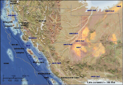
This paleogeographic map is courtesy of Ron Blakey at Northern Arizonal University

Welcome to one of the most unusual (and most isolated) parks in the American Southwest, Goblin Valley State Park. It is located in south-central Utah, miles from anywhere (the relative metropolis of Green River, population 973, is about 50 miles away). It is a fine introduction to the Entrada Sandstone and Summerville Formation, two of the more scenic layers within the San Rafael Group.

In the latest part of the middle Jurassic (around 165 million years ago) huge changes were taking place across the American west. A subduction zone had formed off the coast of California, and compressional forces had caused the faulting and uplift of a range of mountains across Nevada. A shallow sea occasionally extended into the region from the north, leaving vast deposits of mud, silt and sand deposited in tidal flats, while in other areas river floodplains and desert dunes predominated (the region still lay across the subtropical belt, much like the Sahara today). The sediments, which have a distinctive red-brown color, are known today as the Entrada Sandstone.

In other regions, the Entrada is primarily a cross-bedded sandstone that forms distinctive cliffs, but here at Goblin Valley, the formation is more variable, with alternating layers of sand, silt and shale that erode in a differential manner, forming slopes and ledges.

The Goblins are short spires called hoodoos, which resulted from the erosion along joints and fractures in the rocks. If you are a fan of the movie "Galaxy Quest", will immediately recognize the park, and will probably be looking for cute little purple cannabilistic space aliens and immense rock monsters. You will probably be disappointed in your search, but your imagination will probably conjure up even more fantastic creatures as you wander through the goblins.

The park includes a unique campground that is nicely developed with showers and flush toilets but very little shade (there is a nice group campsite too). During the summer we make a point of arriving in the late afternoon when the sun is approaching the western horizon. The views east are expansive, and few parks in the American west offer better star-gazing. The San Rafael Swell, a huge monocline, lies just to the west. The Henry Mountains, one of the last mountain ranges in the United States to be given a name, lie just to the south. Reaching over 11,000 feet, they are a series of laccoliths, a unique type of mushroom-shaped intrusion, almost, but not quite volcanoes (although volcanoes may have once existed above them). The region is also a great place for seeing pronghorn antelope!

Monday, January 14, 2008

Picture of the Day

"Galaxy Quest" anyone? Goblin Valley State Park (central Utah) is one of those little-known out-of-the-way places that is well worth a visit. The nearest town of any size (and that is not saying much) is Green River. There is a pleasant campground, even with showers, and lots of nooks and crannies to explore. The Goblins occur in a member of the Entrada Sandstone, and result from differential erosion on tidal flat mud and sandstone, with the odd shapes of the goblins (which are often called hoodoos) demarcated by vertical joints.