You walk to the edge of the precipice, and you lose all sense of proportion. The rocks at your feet drop off in vertical cliffs into the darkness nearly 2,000 feet below. The opposite rim seems close enough that you are tempted to try and throw a rock across (but it is more than a thousand feet away). You have never seen a canyon quite like Black Canyon of the Gunnison.
It didn't take some of you very long to figure out where
we were in the last vagabonding post; I was describing a place that could have been the much more familiar Grand Canyon National Park, a place with a less visited North Rim, and a heavily trafficked South Rim, but we were in Colorado instead. Black Canyon of the Gunnison National Park preserves one of the most unique canyons in the world, a canyon so deep that cameras start standing sideways in the hands of photographers leaning over the rim. The canyon just doesn't fit in the picture any other way.
The canyon seems impossibly steep. The walls are made of extremely tough metamorphic gneiss and schist, intruded by dikes and sills of equally tough granite pegmatite (an extremely coarse-grained variety of granite; many of the crystals of quartz, feldspar and mica are more than an inch across). The rocks are some of the oldest to be found anywhere in the western United States; they date to Proterozoic time, around 1.7 billion years ago.
A canyon that in many places is deeper than it is wide. It defies belief.
The Painted Wall is the highest unbroken cliff in Colorado with a drop of more than 2,000 feet. The gneiss and schist exposures are dark, while the pegmatite dikes are lighter in color. The rocks record a complex story of continent-terrane collisions, intrusions and mountain-building episodes. The rocks on the rim preserve a relatively flat surface representing a profound amount of erosion...many vertical miles of rock are missing, having been converted into an unimaginable mix of pebbles, sand and mud distributed by rivers that long ago ceased to exist.
The very existence of the canyon is a handy mystery. It carves through what is essentially the top of a mountain ridge, and looking at maps, it looks like the river should be flowing someplace else. One has to drive a long way uphill to reach the south rim. The canyon is an example of a superimposed drainage, one whose pathway was established by external factors (lava flows from adjacent mountains) until it was trapped into flowing across a place that seems to make no sense.
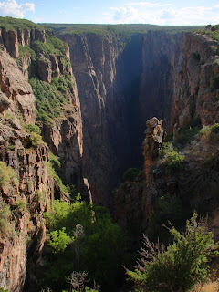
I've been to Black Canyon of the Gunnison many times over the years, but always via the paved roads on the South Rim out of Montrose, Colorado. The park could never be mistaken for a place like Grand Canyon, as it lacks stores, gift shops, hotels, and hordes of tourists. But the North Rim was always mysterious to me.
I could see a single gravel road, and on rare occasions, a car traveling slowly along the edge. The rim was so close and yet incredibly remote, impossible to reach without setting aside a good portion of a day. I wondered what it was like over there, with no pavement, no tourists, just the wind and silence.
My chance to visit the North Rim of Black Canyon happened in July while we slowly made our way home while
vagabonding across Colorado and Utah, roughly following the 39th parallel. We had left the Rocky Mountains behind, and when we crossed McClure Pass, we entered into the Colorado Plateau, the high uplifted region extending across the entire Four Corners region. When we paused in Paonia, an old coal mining town, I glanced at the map and realized we were only a few miles from the remote part of the park. The road was gravel, but not at all difficult to negotiate, and after an hour or so we arrived at the only developed spot, a ranger station. The ranger seemed gratified to have a couple of visitors.
We passed a small primitive campground (mostly empty), and walked out the edge of the abyss. We were alone on the trail. It was a calm day, and the canyon swallowed up any noises. We stared at the cliff faces and marveled at the vertical walls. The patterns of the rock were complex and almost hypnotic.
I loved this place.
We finished our walk and jumped in the Subaru to traverse the rim drive for a few miles. We saw one other car. We couldn't help but stop every few feet to snap another picture. One thing I found amazing was the persistence of life. Mature trees were clinging to life on vertical ridge lines that could barely have enough surfaces to develop soils.
The shadows were getting longer, and we still had quite a few miles to go. We headed out the access road to the north, and found our way back on to the highway to Ouray. We had a nice view north to the Elk Mountains and an interesting looking volcanic neck. It was a nice visit.
The next day we would be heading into Utah...


 We are continuing a march towards the end our narrative on the geological history of the Colorado Plateau, one of the most unique regions on the planet. We've traversed nearly two billion years of strange events culminating in the beautiful scenery that we see today. In the last post, we were exploring a canyon that was missing a river. Today, we are looking at a river that is there, but shouldn't be.
 In our last exploration of the Cenozoic story of the Colorado Plateau, we were looking at a sort of mystery canyon, where a deep gorge had been cut into very tough Proterozoic rocks, but where no river exists today. The name of this beautiful canyon is Unaweep, which in the Ute language means "Canyon with two mouths". That's another view of the canyon in the top picture. To help explain what went on here, I have included a picture of another incredible place in the same region, Black Canyon of the Gunnison National Park. I wrote about the rocks of Black Canyon last year in this post, but had little to say about the location of the canyon itself. Like Unaweep, it doesn't make a whole lot of sense at first.