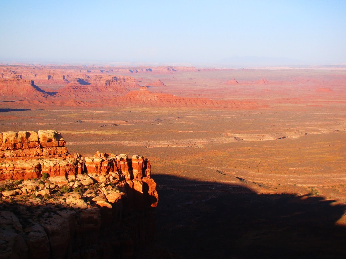
There's an empty quarter within the bounds of the lower 48 states. It's a vast area, a swath of land across southern Utah and northern Arizona where towns are few, and the vistas are wide. It's bounded by Blanding on the east, Mexican Hat and Kayenta to the south, and Lake Powell off to the west. Outside of these few villages there are some reservation lands and ranches. There is a national monument (Natural Bridges), and a national park off to the north (Canyonlands), but mostly it's uninhabited Bureau of Land Management land. In other words, lands held in trust for all the people of the United States.
I've been going through a list of the ten most incredible places I've ever stood, and so far in this series we have explored the
Alaka'i Swamp of Kaua'i, Hawai'i, the
lava flows at Pu'u O'o on the Big Island,
Frame Arch in Arches National Park, the
moment of global death in Gubbio, Italy, and the
Burgess Shale of British Columbia. There was
Siccar Point in Scotland,
Kartchner Caverns of Arizona,
Dante's View in Death Valley, and
Hance Rapids on the Colorado River in the Grand Canyon. I also cheated a little and insinuated that
Glacier Point in Yosemite was one of the ten (which it is, even if all of these add up to eleven; didn't you all see "This is Spinal Tap"?). Some of these I chose because of their geological significance, and some because of their incredible scenery. A few were chosen from sheer emotion and personal spiritual reasons, and that is also the motivation for my number one choice. Not many people know of the place. It's not a national park or monument, and the geology, while interesting, is not exceptional. It's in the center of the empty quarter of Utah on the edge of Cedar Mesa. It's called Muley Point.
Standing on the edge of the world at Muley Point, one looks down several thousand feet into the mysterious gorge of the San Juan River, one of the major tributaries of the Colorado River. The canyon is an intricate twisting maze of curving gorges called
entrenched meanders. The river once flowed as a meandering stream channel over a flat plain relatively close to sea level. When the land rose, the gradient of the river increased, but the water was trapped in the meandering channel, so the curve was preserved as the river cut ever deeper (below).
The rocks making up the cliffs are part of the Cedar Mesa Sandstone, a Permian-aged unit that preserves some coastal sand dunes, and the occasional bone or track of some pre-dinosaurian reptile like Dimetrodon.
 |
| Entrenched meanders of the San Juan River below Muley Point |
In the distance beyond the canyon of the San Juan stand the buttes and mesas of Monument Valley, the scene of so many iconic western movies (below). The valley is administered as a tribal park of the Navajo people. The farthest horizon reveals the margin of Black Mesa, the heart of the Navajo Reservation and the home of the Hopi Nation as well. The spiky monument in the far distance just left of center is Agathla's Needle, the core of a deeply eroded volcano. This volcanic neck, or
diatreme, is similar in age and composition to the better known Shiprock a few miles away in New Mexico.
The view to the east extends across the Raplee Anticline to the Chuska Mountains of New Mexico, and the Rocky Mountains of southeastern Colorado. The scene below is taken from the top of the Moki Dugway on Utah Highway 261, the precarious road that provides access to Cedar Mesa and Muley Point.
 |
| The view east from the top of the Moki Dugway, the spectular road that provides access to Muley Point |
North from the Moki Dugway one can see the deeply incised edges of Cedar Mesa. Looking at this barren desert landscape, it is hard to accept that Cedar Mesa was once part of the "fertile crescent" of the American Southwest. An arc of land extending from Mesa Verde to Cedar Mesa was in the "sweet spot" elevation of being not too hot and not too cold and having just enough precipitation to produce high yields of maize, squash and beans. It was a thriving agricultural region for the Ancestral Puebloan people for hundreds of years. Most of the surface of Cedar Mesa was under cultivation, and thousands of archaeological sites dot the region (unfortunately making it a target for
illegal pothunters). The Puebloans moved on eight hundred years ago, and the mesa has been more or less deserted since then. The juniper and pinyon trees sprouted and covered the ancient corn fields.
Years ago I learned the craft of leading field studies with the staff and crew of Santa Barbara City College, days I remember fondly. We used to take a one-day raft trip down the San Juan River from Bluff to Mexican Hat, and the night before we would spend the night at Sand Island on the river. We would spend a few moments at Muley Point before descending to the hot, humid, and buggy campsite. One year someone pointed out that we were fully equipped to camp anywhere, so why not stay on the rim of Cedar Mesa where the view was indescribable, and the air was fresh and clean, and gloriously free of biting deerflies and mosquitoes? From that time on we camped on the edge of the world. What had been just another spot with a nice view became for me a yearly pilgrimage.

What makes this place so different? It's magic, I think. It is the top of the world, and the edge of the world. One can stand and see a vast region occupied by a mere handful of people, a land that shows little of the damage (at distance anyway) that people can do to a landscape. It's colorful and ever-changing, especially in the light of dusk or twilight. There aren't many places where one can experience the full drama of the Earth through sunset, night and sunrise, and have a completely unobstructed view of the sky from horizon to horizon to horizon.

Usually when we pull into a campsite on our field trips, the students and crew jump out, unpack, and set up their tents and the cooking area. I learned long ago that Cedar Mesa and Muley Point are different. The people emerging from their vehicles disappear. I wander along the edge of the mesa and I find them, sitting alone or in small groups, just contemplating and staring at the scene before them. I often take on the task of preparing the evening's meal just to give them more time to be out there.
I've spent a total of two weeks on the mesa over the last three decades and every night is different. We've seen warm clear days and nights, we've had windstorms (equipments blows over the edge never to be seen again), thunderstorms, and rain.
Have you ever spent an entire night taking in a special place? Have you ever watched the progression of the cosmos over hours and hours of time? We constantly insulate ourselves from the darkness, but there are certain times and places where we can revel in it. There is nothing quite like watching moonlight reach deeper and deeper into canyons below the rim. What had been featureless darkness below becomes an intricate pattern of complex beauty. I've awakened in the early hours of the morning to watch the moon setting or watching the long drama of sunrise. Some nights there are thunderstorms over the Sleeping Ute or Chuska Mountains. The fire in the sky is an incredible sight.
Sometimes there are eerie things as well. Rational people can still feel the echoes of the lives that were played out on this mesa. I've been keenly aware of the spirits that exist in and around the canyons, whether real, or constructs of the imagination. We sat on the edge of the mesa one night nearly thirty years ago and saw mysterious lights. I still to this day don't know what to make of them (and you can be sure that I've watched for their return ever since!). Yet, I've never felt scared or nervous in this place. Just curious.
The morning inevitably comes, and once the sun rises high in the sky, the mesa becomes less mysterious. We are ready for a day of seeking the Ancestral Pueblo ruins that are hidden in literally every side canyon on the mesa. Spending a night exposed to the environment that they called home enlightens our explorations.
It was hard to pick the top ten of my most incredible places, and I couldn't begin to rank them, but I do know that I might not see the Burgess Shale or the Gubbio clay layer or Siccar Point again in my life. They were memorable, and I will always cherish that fact that I got to see them. But I didn't
experience them, not in the way that I've experienced the Grand Canyon, Yosemite, and Cedar Mesa.
That's the thing I guess. Any place in this wide world can become the most incredible place you will ever stand. It won't be that tourist destination that is famous worldwide, because those are the places that you visit once or twice and never get to know. The special places are those which you experience in the fullest sense in all kinds of situations and conditions. That's what Cedar Mesa is to me.

So, what has me worried? I was digging through the tons of old topographic maps in the old department as we prepared for the move to the new Science Community Center. And I found a topo map of the Glen Canyon National Recreational Area, and noticed that a small corner of Cedar Mesa extends over the boundary of the GCNRA. Muley Point is "protected"! But in small print were the following words: "Slated for future development". Chilling words, but thus far unrealized. A paved road, interpretive signs, restrooms, and parking lots would ruin this incredible place. I hesitated about even making its presence known, but in the end I did, because unknown places are the easiest to destroy (just ask Glen Canyon). Such places will need friends in the future.
In the meantime, revel in the discovery of your own most incredible places, and if you are ever near the town of Mexican Hat, seek out Muley Point. It's not too hard to find, the road is okay for most cars even if a bit bumpy at times. And don't just look and drive away after a few minutes. Lay out a sleeping bag, find the appropriate rock (you'll know the right one), and let this place fill you. You won't regret it.
PS: After I posted this, Ron Schott let me know he had a 360 degree gigapan of the view from Muley Point. Check it out at
http://www.gigapan.com/gigapans/52566 !