Showing posts with label Emerald Lake. Show all posts

Monday, September 15, 2014

Northern Convergence: Finally Finding the Edge of North America at Yoho National Park...600 miles inland


Looking upstream on the Kicking Horse River at Field, B.C.
How strange geology is, and what wonderful journeys it provides for our imagination! So many geological processes are exceedingly slow, and yet over time incredible changes occur. How can I be talking about the edge of the continent when we are 1,000 kilometers (~600 miles) from the nearest shoreline?

I've called this narrative of our journey "Northern Convergence" because of the presence of a convergent plate boundary for the last 200 million years or so that has drastically altered and changed the continental margin of Canada and the Pacific Northwest. We had spent the previous four days traversing landscapes composed of exotic terranes, tracts of crust that originated someplace else and had been appended to the edge of the continent by way of subduction. The bits of crust were dragged into the trench, but were too buoyant to sink into the underlying mantle, so they mashed into continent instead, and intense deformation resulted. And the continent got bigger...lots bigger.
Looking downstream on the Kicking Horse River at Field, B.C.
We had crossed the Insular, Coastal, Intermontane and Omineca belts in our four days of driving, covering some 1,000 kilometers (600 miles), and we had finally reached the Canadian Rockies at Yoho National Park. It was here that we finally first encountered the ancestral edge of the North American continent. The limestone and and other sediments in the cliffs high above were deposited in a passive margin setting consisting of debris washed from the ancient continent around 900-400 million years ago. Everything west of our location was from someplace besides North America!

The scenery was on a truly grand scale. Yoho is contiguous with Banff National Park, and yet is rarely mentioned in the same breath (it's always "Banff and Jasper", maybe because they're on the Alberta side, and Alberta knows P.R.). Yet the park is spectacular, and even better, holds a treasure of worldwide significance.
The park protects mainly the upper watershed of the Kicking Horse River which includes several major icefields, including the Waputik and Wapta. The glaciers coming off the icefields contain finely ground silt and clay that stay suspended in the turbulent water. The rivers look like flowing milk at times.
Glacial "milk" also changes the appearance of lakes. In the calm water some of the clay begins to settle out forming a translucent turquoise color that is very striking. We made a stop at Emerald Lake to talk about the glaciers and have a look at the high ridge where the Burgess Shale was exposed.
Another road reaches up into the Yoho River drainage, providing access to Takakkaw Falls, the third highest in Canada at 254 meters (833 feet). The waterfall is a textbook example of a hanging valley, resulting when the main trunk glacier carved a deeper valley than the tributary glacier. The glacier feeding Takakkaw Falls is only a kilometer or so upstream of the brink.

If you need a sense of scale regarding 254 meters, look at the picture above where the water leaps outward from the cliff near the top of the waterfall. Let's zoom in on it. Those little dots to the left? Rock climbers!
All in all, Yoho National Parks is one of the most dramatic landscapes imaginable, but it's the rocks themselves that hold the real treasure. Although mining took place here last century, the treasure is in the fossils found in these rocks. About half of our crew were not with us as we toured the park, as they had left early in the morning to complete a tortuous 12 mile hike to see the quarry where the Burgess Shale fauna was discovered more than a century ago.

There is a problem with understanding the ecosystems that existed millions of years ago. Usually only the shells and bones are found, but the vast majority of organisms had soft bodies that are rarely preserved as fossils. They would invariably decay quickly. Fossil localities with the remains of soft-bodied organisms are few and precious, and our students were investigating one of the world's most famous. The Burgess Shale preserves the fossils of soft-bodied organisms that were present only a few million years after the dawn of complex multi-celled lifeforms.
How did they come to be preserved here? Just over 500 million years ago, the region was at the edge of the continent in relatively shallow water at the edge of the continental shelf. The shelf was unstable and occasionally a mass of mud would break off and sink into deeper water, carrying with it the organisms that were living there. The blocks sank into oxygen-starved water where the bacteria that would have consumed the soft body tissue could not survive. Mud covered and preserved the dead organisms. More than a hundred species have been described here.

The fossil quarry lies high on a ridge above Emerald Lake between Field and Wapta peaks. You can pick it out in the picture below, as the horizontal gash in the hillside with the lowest patch of snow. The hike is not easy, really an all-day affair. The quarry is a World Heritage Site and access is strongly restricted, and obviously collecting is not allowed. I've heard they've even gone after fossil sellers active on E-Bay.
I did the hike in 2005, so I didn't try it this time, opting instead to let my fellow professor hike with the students (she might forgive me the blisters one of these days...). The hike was one of the great adventures of my life, though, and I described it in detail in a post last April: you can read it by clicking here. There just aren't many times in life when you can be so close to the ancient past.
Holding a specimen of Marrella splendens in the Burgess Shale quarry, 2005

We visited with the local wildlife, and then headed over Kicking Horse Pass into Banff National Park. More adventures lay ahead!
A Black-billed Magpie (Pica hudsonia) at Field, B.C.

I hope that somebody appreciates that I made it through an entire post about a place named "Yoho" with nary a single "Pirates of the Caribbean" joke.

Thursday, April 24, 2014

Where are the Ten Most Incredible Places You've Ever Stood? My Number 8: The Burgess Shale in British Columbia

The journey continues through the ten most incredible places where I've ever stood. Every person's list will be different; I'm hoping to hear of great ideas for future travels! Number ten for me was the Alaka'i Swamp of Kaua'i. Number nine was Frame Arch in Arches National Park next to Delicate Arch, Frame's better-known counterpart. This next one was an easy post because one of the Accretionary Wedge topics asked a similar question, i.e. What is your geological pilgrimage – the sacred geological place that you must visit at least once in your lifetime? What follows is a slightly abridged post from the wedge topic in April of 2012. Keep in mind that no order is implied with these posts, except for number one.

I've had a rich life, being able to link my favorite activities, traveling and photography, with my career as a geologist and teacher. It means I have been to a lot of places, so determining a list like this leads to a lot of introspection. I've been enjoying reading some of the other entries...I like new ideas of where to go!

I settled on this one particular site because of the emotional impact it had when I reached the goal. It was indeed remote and difficult to get to. It was the Burgess Shale fossil quarry in Yoho National Park in British Columbia, Canada. Besides being one of the most important fossil sites in the world, it involved one of the most beautiful hikes I've ever taken. Just look at the scenery from the edge of the quarry:
Fossilization is a chancy process. Everything has to happen just right, and most of the time organisms are immediately scavenged or quickly decay. Even when things happen just right, it is exceedingly rare for anything besides bone or shell to survive. As a result, the fossil record is highly biased towards creatures with shells. When one considers how many soft-bodied creatures exist in the world's ecosystems, and how rarely they are preserved, we realize how poor our picture of the past really is. This is especially true of the "dawn" of complex life in the Cambrian period, just over 500 million years ago. Something 75% of the record is made up of the various species of trilobites, and most of the rest are sponge-like archaeocyathids and brachiopods (simple bivalved creatures which are not as "advanced" as clams). Although we know that plenty of soft-bodied forms existed, they have not been preserved, except in a precious few places.

One of these is the Burgess Shale, in British Columbia. The shale accumulated as masses of mud slid into oxygen-poor water. The organisms living in the environment were killed immediately, as were the scavengers and microbes that would have consumed them. The outcrops were discovered by Charles Walcott in 1909, and over the years tens of thousands of specimens have been collected and analyzed. The rocks were full of diverse and sometimes bizarre species that would have otherwise been lost to all time (see this article for examples).

The Burgess Shale is high on a ridge in the Canadian Rockies, and it is a tough six mile hike to the quarry. As a World Heritage Site, and being within a Canadian National Park, access is highly restricted (and believe me, they know when someone is there illegally!). To see the quarry one must go with a conducted tour through the Burgess Shale Geoscience Foundation.
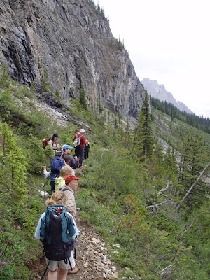
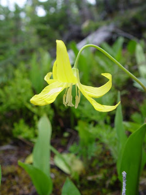
I made the hike in July of 2005, one of the first hikes that year in this cold alpine environment. The sun played hide and seek with the clouds, and rain occasionally threatened (I have the distinct impression that that situation occurs just about every day up there). Glacier Lilies were everywhere, providing a great deal of color along the trail. There were also several steaming piles of grizzly bear poop, so we stayed pretty close together on the trail...
It was a long uphill hike, but after 5 1/2 miles, we passed a sign that let us know we were drawing close.
I walked a little slower than the others, and I paused at the last few steps. Most of the other hikers were not geologists, and were only beginning to understand the importance of this site to paleontology. I gathered my thoughts and emotions, and stepped into the quarry for the first time.
It was still half-filled with snow and ice, but there were plenty of slabs of rock around. Trilobites were all over, and I almost immediately found a delicate sponge fossil. The others gathered at the far end of the quarry, so I walked over.
The foundation knows that random searching in the quarry will not reveal some of the rare creatures, so they keep some pretty decent samples in the red lockbox on the site. Gazing at the specimens, I realized all over again what a wondrous treasure this site this really is for paleontologists.
Collecting of course is not allowed here, but we were allowed to search among the slabs for fossils that we could "own" for ourselves through the magic of digital imagery. I quickly found a nicely preserved Haplophrentis, a primitive mollusk related to snails and clams.
My favorite find was a complex little Marrella species, which is actually the most commonly found fossil in the Burgess Shale. It was the most delicate fossil I've ever found. And hard to photograph!
I tried photographing the fossil from a couple of angles. The brown spot is a stain of fluids that escaped when the organism died. In case you are wondering, no, the specimen didn't "accidently" fall into my pocket. I put it in the pile next to the big red box, so look for it if you ever get up that way.
If you are having difficulty making out the specimen in the pictures above, check out the reconstruction in the picture below to get an idea of the complexity of the little creature. Something close to 180 species of creatures have been found in the shale, and perhaps only 2% would have been preserved in Cambrian sediments anywhere else in the world. The fossil record certainly has a bias that favors animals with hard shells or skeletons.
Marrella splendens Source: http://burgess-shale.rom.on.ca/en/fossil-gallery/view-species.php?id=80&m=3&
The rain started to fall, so we started down the barren slope. It's not a very smart place to be in a lightning storm! During the hike down, I was no longer so anxious about reaching the goal. I strolled along, enjoying some of the finest alpine scenery I have ever laid eyes on.

Emerald Lake, thousands of feet below, really looked more turquoise in color, due to the fine clay particles suspended in the water. Glaciers are still carving these mountains.
After about ten hours and 12 miles on steep trails, I arrived back at the parking lot, tired but happy. It was indeed a place worthy of a geological pilgrimage, and easily made my top-ten list of the most splendid places I've ever stood.

Monday, April 30, 2012

When Life Got Complicated: the Burgess Shale (Accretionary Wedge #45)

Life as a Geologist is our host for Accretionary Wedge Carnival #45. And what a great topic:
"Geological Pilgrimage – the sacred geological place that you must visit at least once in your lifetime ....a single place, which is “geologically” unique, relatively remote, and requires some difficulty to get to. If you have already done your geological pilgrimage, please share with us your experience..."

I've had a rich life, being able to link my favorite activities, traveling and photography, with my career as a geologist and teacher. It means I have been to a lot of places, so a topic like this leads to a lot of introspection. I'm also looking forward to reading some of the other entries...I like new ideas of where to go!

I thought of a lot of places, but I settled on one particular site because of the emotional impact it had when I reached the goal. It was indeed remote, and was difficult to get to. It was the Burgess Shale fossil quarry in Yoho National Park in British Columbia, Canada. Besides being one of the most important fossil sites in the world, it involved one of the most beautiful hikes I've ever taken. Just look at the scenery from the edge of the quarry:
Fossilization is a chancy process. Everything has to happen just right, and most of the time organisms are immediately scavenged or quickly decay. Even when things happen just right, it is exceedingly rare for anything besides bone or shell to survive. As a result, the fossil record is highly biased towards creatures with shells. When one considers how many soft-bodied creatures exist in the world's ecosystems, and how rarely they are preserved, we realize how poor our picture of the past really is. This is especially true of the "dawn" of complex life in the Cambrian period, just over 500 million years ago. Something 75% of the record is made up of the various species of trilobites, and most of the rest are sponge-like archaeocyathids and brachiopods (simple bivalved creatures which are not as "advanced" as clams). Although we know that plenty of soft-bodied forms existed, they have not been preserved, except in a precious few places.

One of these is the Burgess Shale, in British Columbia. The shale accumulated as masses of mud slid into oxygen-poor water. The organisms living in the environment were killed immediately, as were the scavengers and microbes that would have consumed them. The outcrops were discovered by Charles Walcott in 1909, and over the years tens of thousands of specimens have been collected and analyzed. The rocks were full of diverse and sometimes bizarre species that would have otherwise been lost to all time (see this article for examples).

The Burgess Shale is high on a ridge in the Canadian Rockies, and it is a tough six mile hike to the quarry. As a World Heritage Site, and being within a Canadian National Park, access is highly restricted (and believe me, they know when someone is there illegally!). To see the quarry one must go with a conducted tour through the Burgess Shale Geoscience Foundation.
I made the hike in July of 2005, one of the first hikes that year in this cold alpine environment. The sun played hide and seek with the clouds, and rain occasionally threatened (I have the distinct impression that that situation occurs just about every day up there). Glacier Lilies were everywhere, providing a great deal of color along the trail. There were also several steaming piles of grizzly bear poop, so we stayed pretty close together on the trail...
It was a long uphill hike, but after 5 1/2 miles, we passed a sign that let us know we were drawing close.
I walked a little slower than the others, and I paused at the last few steps. Most of the other hikers were not geologists, and were only beginning to understand the importance of this site to paleontology. I gathered my thoughts and emotions, and stepped into the quarry for the first time.
It was still half-filled with snow and ice, but there were plenty of slabs of rock around. Trilobites were all over, and I almost immediately found a delicate sponge fossil. The others gathered at the far end of the quarry, so I walked over.
The foundation knows that random searching in the quarry will not reveal some of the rare creatures, so they keep some pretty decent samples in the red lockbox on the site. Gazing at the specimens, I realized all over again what a wondrous treasure this site this really is for paleontologists.
Collecting of course is not allowed here, but we were allowed to search among the slabs for fossils that we could "own" for ourselves through the magic of digital imagery. I quickly found a nicely preserved Haplophrentis, a primitive mollusk related to snails and clams.
My favorite find was a complex little Marrella species, which is actually the most commonly found fossil in the Burgess Shale. It was the most delicate fossil I've ever found. And hard to photograph!
I tried photographing the fossil from a couple of angles. The brown spot is a stain of fluids that escaped when the organism died. In case you are wondering, no, the specimen didn't "accidently" fall into my pocket. I put it in the pile next to the big red box, so look for it if you ever get up that way.
The rain started to fall, so we started down the barren slope. It's not a very smart place to be in a lightning storm! During the hike down, I was no longer so anxious about reaching the goal. I strolled along, enjoying some of the best alpine scenery I have ever gazed on.

Emerald Lake, thousands of feet below, really looked more turquoise in color, due to the fine clay particles suspended in the water. Glaciers are still carving these mountains.
After about ten hours and 12 miles on steep trails, I arrived back at the parking lot, tired but happy. It was indeed a place worthy of a geological pilgrimage.