Friday, July 7, 2017
Just How Big is Mt. Shasta in Northern California? Getting a sense of scale...
Mt. Shasta is a big mountain. It becomes visible from upwards of a hundred miles away. Topping out at 14,180 feet (4,322 m), it has the greatest volume of any Cascades stratovolcano at around a hundred cubic miles of lava flows and ash (the less visible shield volcanoes like Medicine Lake Highland are larger however). Driving north on Interstate 5, the mountain edifice takes on the very definition of "looming".
On our recent journey through the Pacific Northwest, Mt. Shasta was our first lecture stop. We drove up the flank of the mountain to an elevation of 7,000 feet or so at Bunny Flat, where we were stopped by snowdrifts...in late June. It's been a wet year!
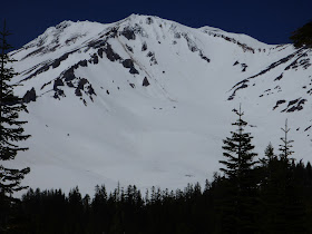
It's hard to get a true sense of scale sometimes when observing really big mountains, but my camera has a pretty dandy zoom lens, so I had a bit of fun with it. In the picture above, note how the center of the picture is completely snowbound, except for three rocks near the top of the ice slope. I zeroed in on it.
In the photo above, we can see those three large rocks a bit more clearly. Keep in mind that we are already 7,000 feet up the mountain. There is more than a mile of mountain above us.
Zooming in once more, we can see that there is more than just three big rocks on the slope. It's hard to get a sense of how big they might be, except that at this scale we can see some more very small black dots scattered about the slope. What could they be?
At the highest zoom (60x), the small dots resolve into human beings. It was a hot day in the valley, so a lot of people were up on the slopes of Mt. Shasta keeping cool. And yes, Shasta is a very big mountain.


I wasn't aware of a ski resort on Mt. Shasta. Did those skiers hike up?
ReplyDeleteThose are climbers, and they hiked up. There used to be a ski area at the end of the road we were on (The Everitt Highway), but it was closed and dismantled because of ongoing avalanche danger. There is a Mt. Shasta Ski Park lower down on the mountain, accessed from Highway 89.
ReplyDelete