The Great Valley began as a forearc basin, a sequence of sedimentary layers lying on oceanic crust between a subducting trench and the edge of the North American continent. The sediments were derived from the erosion of the Ancestral Sierra Nevada, which at the time was a string of volcanoes not unlike the Andes or Cascades of today.
 |
| Source: https://commons.wikimedia.org/wiki/File:Franciscan_subduction_model.gif |
What a fascinating time this was! Huge volcanoes were erupting every few decades, while large rivers were constantly eating away at the mountains. A diverse group of dinosaurs roamed the forests on the flanks of the volcanoes including hadrosaurs (duckbilled dinosaurs). Raptors and carnivores similar to T-rex and Deinonychus (the American version of the velociraptors) lurked in the trees and along the rivers. Various species of Pterosaurs flew overhead.
 |
| The first dinosaur found in California was discovered on this ridge above the landslide. |
 |
| Fall colors in Del Puerto Canyon. Unlike the rest of the country, we believe in enjoying the fall until winter actually begins on the calendar. |
The sediments accumulated to an incredible thickness, more than 25,000 feet. The sediments were later twisted upwards to form the eastern flank of the Coast Ranges. The road in Del Puerto Canyon winds for more than 10 miles through the sandstone, siltstone, and shale that once formed the ocean floor. We were driving up canyon, but deeper down into the crust. We were looking for the Tesla-Ortigalita fault that marks the boundary between the so-called Great Valley Group, and the underlying Coast Range Ophiolite, a slice of oceanic crust.
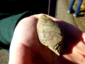
We soon reached the rocks near the base of the Great Valley Group, and found the exposure of the fault zone (it cuts diagonally upwards to the left in the picture above). I visited this spot nearly twenty years ago with Al Bennison, who by then was long retired. He described the structural relationships to us, and pointed out that ammonite fossils (cephalopods related to the Pearly Nautilus and the Octopus) could sometimes be found in the shale on the right side of the fault. He walked over, glanced at the cliff for a moment and said "here's one", handing me the delicate fossil. I've been to that darned outcrop another twenty times or so over the years, and I've never found one for myself!
So of course, what happens when I take our Geology Club students to the outcrop last Saturday, students who have never seen this spot, some of whom haven't even learned about ammonites yet? Yes, they found one. Durn it all....
At this point we've driven 10 miles into the canyon, and passed through five miles of seafloor sediments. We've reached the top of the oceanic crust, known in this area as the Coast Range Ophiolite, one of the most complete such sequences in all of California. For the next part of the journey we sought to pierce the crust and travel into the Earth's mantle below. We continued up the canyon...


Garry - you write about such accessible geologic sites. I wanna go here!
ReplyDeleteEnjoyed this Garry. I assume more will follow?
ReplyDeleteAt least two more. We need to make our way through the crust, and then the mantle.
ReplyDelete"we believe in enjoying the fall until winter actually begins on the calendar." -- yeah, ok, rub it in! But on the other hand, you aren't cross-country skiing like we are ;-) (when the highways are open that is)
ReplyDeleteNot to rub it in even more...I COULD go cross-country skiing by driving up to the snow...
ReplyDelete