As you can see in the picture above, Mattole Beach was horrifically crowded, and we could hardly find a bare patch of sand to call our own. Well, okay, not so crowded. The small campground was half full, though. This region is where three plate boundaries come together: a triple junction. It is a geologically active zone, with a number of magnitude 7+ earthquakes over the last century, including a particularly nasty event in 1992 (magnitude 7.2) that caused serious damage in Petrolia, Ferndale, and Eureka.
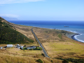
The event lifted the coastline several feet in places. The coastal plain near Sugarloaf Island (below) is actually a wavecut bench that has been lifted several tens of feet over the last few thousand years. Waves once scoured the surface at the ranch buildings.
Sugarloaf Island is situated just offshore of Cape Mendocino. From here north, the Cascadia Subduction Zone rules the geology. Quakes along the zone can be huge, as great as magnitude 9. The last occurred just over 300 years ago in 1700. It generated a tsunami that caused damage in Japan.
At this point, Mattole Road left the coast and climbed steeply over a series of ridges to Ferndale. Each of the ridges were fault blocks separated by thrust faults. This is a dangerous landscape!
Posts will be sketchy over the next few days or weeks as we camp our way north through Cascadia.


Great photos, I live up here and it's marvelous to see you've visited a couple of times, fabulous geology ... and such fun...
ReplyDeleteA good article:
ReplyDeletehttp://www.newyorker.com/magazine/2015/07/20/the-really-big-one