It seems that one subduction zone wasn't enough for California. There have been at least two. The metamorphic rocks of the Sierra Nevada Mother Lode are the remains of the earlier zone, which was active during the Mesozoic era. Sometime in the Cretaceous period the subduction skipped west to become the Franciscan Subduction Zone that we have been exploring throughout the first part of this series on the most dangerous boundary in the world.
One might expect the rocks of the Mother Lode, having formed in the same manner as those of the Coast Ranges, would look the same. But they are a world apart. Why the difference? The older rocks have undergone some serious metamorphism over the long ages. Metamorphic rocks are those which have been changed by heat and pressure into a harder, denser form than the original rock. Shale (which is a soft rock that forms easily eroded slopes in the Coast Ranges) is transformed into slate or phyllite, hard rocks that can resist erosion, forming prominent "tombstone rocks" in the Sierra foothills. Volcanic rocks like basalt or andesite will change to an equally tough rock called greenstone, because the rock is, well, often green in color. Serpentine is commonly found in relation to the fault zones.
One of the most spectacular rocks formed when coral reefs or limestone terranes were added into the subduction zone chaos. The rock metamorphoses into marble, and being made of the mineral calcite, is easily dissolved when immersed in slightly acidic groundwater. Caverns are the result and there are hundreds of them in the Mother Lode. Natural Bridges (below) are accessible by a short trail near New Melones Reservoir. A small tributary of the Stanislaus River, Coyote Creek, flows through two caverns, partly composed of spring deposits.
The site is free and is popular in summer, especially for inner-tubers who float through the caves. At other times of the year, the caves are quiet and contemplative. Getting there requires hiking a relatively gentle mile-long trail.
The metamorphic rocks of the Mother Lode consist of three (actually more, but let's keep things a bit uncomplicated) terranes which become progressively older to the east. They include the Foothills terrane (with mostly Mesozoic rocks), the Calaveras Complex (late Paleozoic and early Mesozoic rocks), and the Shoofly Complex (the oldest, containing Paleozoic rocks). One of the best ways to see them is to follow Hornitos Road to Highway 140 through Mariposa, following the Merced River to Yosemite. The town of Mariposa and the Melones Fault are the boundary between the Foothills rocks and the Calaveras Complex. The boundary with the Shoofly is less obvious, but lies a short distance upstream from the "Geological Exhibit" near Savage's Trading Post on the Merced River.
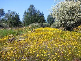
Follow the route at the right time in the spring and you will be treated to a flower show that will astound. Imagine slopes a thousand feet or more covered by poppies and lupines. It didn't happen to any great extent this last spring though; the ongoing drought affects many aspects of life.
At the geological exhibit, one can view some spectacularly folded chert deposits in the river channel. The chert began as one-celled creatures in the open seas of the Pacific Ocean. The thick powdery rock (diatomite) was compressed and altered to the much denser and harder chert. It was swept into the subduction zone where it was deformed. These rocks bear a strong resemblance to the chert of the Marin Headlands.
Up next: the culmination of our journey through the most dangerous plate boundary in the world!


Welcome back Gary! The last photo of metamorphic rocks captivated me. It made me question the boundary between folded sedimentary rocks, such as displayed at the parking lot of Calico ghost town (if I'm correct in describing them as such), and the picture just referenced.
ReplyDeleteGorgeous fotos and landscapes.
ReplyDelete