We continue our drive through the most dangerous plate boundary in the world (past tense, since it became inactive 20 million-plus years ago), and we've arrived at the Marin Headlands, one of the most beautiful coastlines in the world, and a marvelous exposure of what I've called geology's junk drawer, the accretionary wedge of a subduction zone. The rocks of the wedge are called the Franciscan Complex, and it's appropriate, given the chaotic nature of the rocks
We are taking a little detour from our drive from Point Reyes, and tooling about the headlands on Conzelman Drive. But even before that, I didn't want to miss a gem of a national monument tucked away in the depths of the headlands, Muir Woods.
Muir Woods preserves one of the small remnants of old-growth Redwood forest left in California. More than 95% of the original forests have been cut down, and the northern Coast Ranges have been deeply altered, and the ecosystems shredded. The native range of the Coast Redwoods and the extent of the Franciscan Complex correspond closely, but I don't think the relationship is necessarily biological. The trees need the climate afforded by the proximity of the Pacific Ocean, and the Franciscan Complex is a young rock unit that formed parallel to the same coastline.
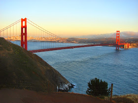
As pointed out in the previous post of the series, the Marin Headlands are somewhat unique, having a higher than usual percentage of sea-floor ribbon chert exposures and the underlying pillow basalts of the ocean crust. As we start up the Conzelman Road, we get some marvelous views of the Golden Gate and the orange bridge that crosses it (see the top photo). In the parking areas people use to stare at the bridge, there are marvelous exposures of the chert and basalt.
The chert and basalt have been metamorphosed to some extent and deeply deformed, but the rocks still show much of their original nature. In some of the roadcuts, the chert can be seen lying directly on the sea-floor basal. Geologists have figured out that the sequence preserves about 100 million years of deposition (from 200 to 100 million years ago). This is an extraordinarily long record of slow travel of the plate across the Pacific Ocean.
The scenery is extraordinary along the road. The Golden Gate rises out of the sea in bold cliffs, and though the headlands have been altered by road-building and military activity, the region today exudes beauty and serenity.
Wait, what? Military activity on these beautiful cliffs? Why?
When World War II was being fought, San Francisco Bay was one of the most important strategic strongholds for the entire Pacific Theater of operations. There was the harbor itself through which much of the fleet operated, factories and ammunition depots, and the inland agricultural areas. That and a huge civilian population. The hills above the Golden Gate were studded with huge cannons and guns that could wreak devastation on any enemy flotilla that tried to enter the harbor. Below is Battery Mendell, just north of the Point Bonita Lighthouse.
The Marin Headlands region is a stunningly beautiful place with a fascinating geological story. The area is protected as part of the Golden Gate National Recreation Area, which is more or less equivalent to a national park. It is certainly a popular destination, but it's usually possible to find some quiet corners, especially if you are willing to hike a little. In our next post, we'll head down to the beaches of the Marin.


No comments:
Post a Comment