 |
| Drake's Beach, with outcrops of Purisima Formation that reminded early sailors of Dover. |
For many millions of years, oceanic crust and exotic terranes were carried eastward towards the continent, only to be forced beneath the edge of North America (subducted). Eventually the source of oceanic crust, the East Pacific spreading center, made contact with the convergent margin and subduction ended. Because of the relative motion of the two plate edges, a new fault system developed, the San Andreas, and a portion of Southern California began to move northwestward along the new fault. Such zones that divide crustal plates from one another are called transform boundaries. Granitic rock that had formed as part of the Sierra Nevada Batholith was sliced off from the south end of the province and was carried north several hundred miles (see below). The displaced granitic rocks are referred to as the Salinian Block.
The Point Reyes Peninsula is one of the more intriguing corners of California. It's connected to the California Coast Ranges after a fashion but it is a world apart. Tomales Bay, Olema Valley, and Bolinas Lagoon mark the location of the San Andreas fault. The epicenter of the infamous 1906 San Francisco Earthquake was close to Point Reyes, and offsets totaled close to 20 feet during the magnitude 7.8 seismic event.
The peninsula is protected from development as Point Reyes National Seashore, and is a haven for wildlife. During my visit several years back I captured my best shot ever of a California Quail. On our way to the beaches, we saw a herd of Tule Elk.
The Peninsula has several distinct geological sections. The mountainous terrain of Inverness Ridge is composed mostly of the granite and metamorphic rocks of the Salinian Block. Much of the western and southern parts expose sedimentary rocks of Miocene and Pliocene age. During the journey northwest from Southern California, the peninsula was submerged beneath the ocean waves. Active dune fields can be found along the extensive beaches of the peninsula.
Drake's Estero is an interesting feature. The branching arms of the bay suggest that it is a submerged river valley. The shallow water has proven to be a good spot for oyster farming, and the 80 year old business is embroiled in a battle with the park service over land-use issues.
 |
| Source: USGS (http://pubs.usgs.gov/of/2005/1127/) |
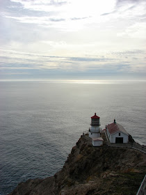
The rocky headland where the lighthouse is located is composed of granitic rock and some of the overlying late Cenozoic sedimentary rocks. The lighthouse is visible from as far as 24 miles away, but fog obscures the view for around 140 days a year. Winds are nasty (highest recorded was 133 mph), and the temperature generally hovers between 50 and 60 degrees Fahrenheit all year.
Reaching the lighthouse requires descending 300 steps, but during the rare clear days, the spot is one of the best in California for whale-watching. Expect crowds on the nice days...
 |
| Steps leading to the Point Reyes Lighthouse |
 |
| Point Reyes Lighthouse, constructed in 1870 |


My family and I will be visiting Point Reyes next weekend. I hope my pictures are at least half as good as yours!
ReplyDeleteThis is one of my favorite places to ride my bike. I am fortunate to be able to get out there a couple of times a year.
ReplyDeleteI'm pretty sure the epicenter for the 1906 quake was located off the coast of SF, and not located in the Olema Valley section of the San Andreas as had been previously believed due to ground offset.
Gabe