Thursday, January 28, 2016

Dreams of Summer: Going Underground on New Mexico's Continental Divide


When one thinks of the Continental Divide, one might imagine high peaks of the Rocky Mountains, piercing the sky with glacially carved ridges. It's not always quite that way. As we made our way last summer across the flat plateau lands east of Petrified Forest National Park, we passed the Zuni Pueblo, and reached a forest of Ponderosa pines.
The flat highway crossed a barely perceptible rise, and we almost missed a sign that said we were crossing the Continental Divide. Somehow, we had driven to an elevation of more than 8,000 feet and barely noticed. We crossed the divide and entered El Malpais National Monument.
It was late in the day and we were on a tight schedule, so we didn't have time to explore this strange and wonderful landscape as much as we might have wished, but we couldn't pass up the chance to go underground for a while.
El Malpais (Spanish: "Bad Lands") lies at the edge of the Colorado Plateau where it drops off into the Rio Grande Rift. The rift valley a vast fault trough where the continent started to split apart starting 30 million years ago. Rifting is never a gentle process, and the tearing of the crust allows magmas to form and erupt. Most of El Malpais National Monument is a geologically recent series of basalt flows, the youngest ranging in age from 2,500 to 17,600 years ago.
Basaltic lavas are more fluid than silica-rich lavas like andesite or rhyolite. They can flow for miles before cooling, but the flow is aided by the formation of a crust on the surface. The crust acts as insulation, keeping the lava hot and fluid. At times, especially near the end of the eruption sequence, the lava drains from under the crust, leaving behind a system of linear caves called lava tubes. That's what we were visiting that evening. There are undoubtedly many lava tubes in the park, but four are specifically open for exploration.

Junction Cave is several hundred feet long and is easily accessed at the end of a short trail off the main highway. If you intend to visit, be sure to get a free permit from the visitor center. The cave is bat habitat, and the park is extremely worried (with good reason) that the white-nose fungus might attack the bats. The fungus has decimated bat populations back east, and has been moving west over the last few years.

Lava tubes are not "decorated" in the manner of limestone caverns, as solution (the origin of stalactites and the like) is not a prominent process in the volcanic rocks. On the other hand, there are occasionally flow structures and drip structures ("lavacicles") that can be seen. Some of the caves may even preserve ice masses long after winter has ended (there is a commercial ice cave at the park boundary).

New Mexico is famous for caves, Carlsbad Caverns being one of the premier caves of the world. But in some little forgotten corners there are interesting caves of a completely different kind.

Tuesday, January 26, 2016

Late to the Party, but here's the 7.1 Magnitude Alaska Earthquake as Recorded from Central California


An earthquake, large by California standards, but almost moderate by Alaska standards, hit on Sunday, January 24 southwest of Anchorage. It measured 7.1 on the magnitude scale (moment magnitude). The quake was on a strike-slip fault (lateral motion), and was thankfully relatively deep (128 km/80 miles). Deep is good because the waves had to travel 80 miles just to get to the surface; it's like being 80 miles away from the epicenter of a shallow quake. Because of this, the damage was minor.

Our recording device is a simple classroom demonstration seismometer, but it has proven capable of catching a good record of large distant quakes, and smaller local ones. It's available for less than $1,000 at science supply outlets like Wards Science.

Monday, January 25, 2016

A Modesto Junior College Field Studies Opportunity: Geology and Archaeology of the Hawaiian Islands, June 1-13, 2016


This might be of interest only to my Modesto area readers, but anyone who is interested in learning about the natural and human history of the Hawaiian Islands may want to investigate this field studies opportunity June 1-13, 2016.

Imagine yourself on a journey exploring volcanoes, coral reefs, deep mysterious canyons rivaling the Grand Canyon, tropical rainforests, tropical deserts, ancient foot trails and petroglyphs while learning geology and archaeology in one of the finest outdoor laboratories on the planet! The Hawaiian Islands are scientific and cultural treasure! Our MJC summer field studies course  will be a multidisciplinary study of the Hawaiian Islands, with nine days on the Big Island, and four days on Kaua'i. This will be a dyad class, Geology 190 and Anthropology 190. Cost for lodging, transportation and inter-island flight will be $2,200 (students will need to meet us in Hawaii, and arrange their own food). An informational meeting will be held Thursday, January 28 (5:30 PM in Science Community Center Room 326). We welcome the participation of interested students, community members, and staff members at MJC.
Contact me (hayesg "at" yosemite.edu) for more information. There is a course web page at http://hayesg.faculty.mjc.edu/Hawaii_2016.html, and a facebook group page at https://www.facebook.com/groups/452708258272005/. If you can't make it to the information meeting in person, please contact us; we'd be glad to have you join on this great expedition!

Wednesday, January 20, 2016

The Rains Come and the Snow Falls: Normal in California Doesn't Feel Normal

Normal just doesn't feel normal.

In 2014, researchers were declaring the California drought the worst in 1,000 years. And then we had a year, 2015, that was in many ways much worse. We actually had near normal rainfall on the valley floor that year, but it was so warm that the snowpack ended up at 10% of normal, a value never recorded previously. It has been a horrific time. Not only are the reservoirs low and agricultural fields dying away, groundwater has been overdrafted at catastrophic rates, and the worst wildfires in living memory have destroyed vast swaths of forests in the Sierra Nevada and Southern California.
Dry Creek, January 20, 2016
It's not going to get all that much better. Climate models are suggesting that megadroughts, lasting decades, will be the norm starting in about 30-40 years. So this year has been one of hope, in California anyway. El Nino, the climate phenomena that causes all kinds of chaos across the world, tends to bring lots of rain to California (it also unfortunately brings drought elsewhere).

The storms so far have actually not been directly related to El Nino. They have been cold arctic storms that have been dropping prodigious amounts of snow in the Sierra Nevada. For the first time in five years, the snowfall has been above normal. Not far above normal, around 110-115%, but it feels unprecedented after such a long period of paltry precipitation.

The climate of the floor of the Great Valley is semi-arid to desert. The winter rains don't contribute much to the agricultural yields, but wet years are important, as they allow for some recharge of the groundwater. It's never been enough, so our groundwater "savings account" is always shrinking overall.

So I've been watching the precipitation pretty carefully of late. Well, actually I've been tracking rainfall amounts in my backyard rain gauge since 1991, and this year has been interesting. At 2.82 inches, the November rain was the second highest I've recorded. December didn't set records, but 2.60 inches fell that month. But once January arrived, the spigots opened up, and we've four good storms already, dropping 4.21 inches. We've already reached 10.01 inches for the year, where 12 inches is average for an entire season.
Dry Creek on January 7, 2016
Two weeks ago, I noted that Dry Creek, a minor tributary to the Tuolumne River, was "flooding". The earlier storms had only been percolating into the dry soils upstream, but the first heavy storm in January ran off, producing a flow in excess of 1,000 cubic feet per second. We got two more inches of rain in the last three days, and Dry Creek was flowing at nearly 3,000 cubic feet per second this morning. It was a delightful sight.
Dry Creek in March 2011, at more than 3,000 cfs
The future is hard to predict. Last year, we had a wet autumn, but there wasn't a single drop of rain in January, and what little snow had fallen quickly melted away. According to the climate models, the El Nino storms will be starting to affect California in a matter of weeks, bring intense warm storms, primarily to Central or Southern California. There can be no doubt that we need to fill our depleted reservoirs, if for no other reason than to stop depending on groundwater during the irrigation season.
Merced National Wildlife Refuge, January 2014
But I also worry about the health of our regional wild habitats. The wildlife refuges of the Great Valley are critical roosting places for millions of migratory birds, and they tend to be at the low end of priority for water allocations. The rivers that I love, the Merced, the Tuolumne, and the Stanislaus, have been running low and warm, killing tremendous numbers of native fish, and allowing the spread of invasive Water Hyacinth. We've taken over 95% of the natural habitats of our valley, and have a responsibility for taking care of what little remains.

It's been normal, but it doesn't feel normal.

Tweaks to Geotripper

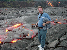
So I look at my blog today, and a bunch of stuff looked different. I don't know how or why because I haven't touched the "layout" button in a long time, but since the arrangement looked terrible, I made some tweaks, mainly trying to make the links easier to read. Anyway, we will return to our regular programming as soon as possible. The picture is a New Mexico teaser, a sneak peek at a very cool intersection between human life and geological processes.

Saturday, January 16, 2016

Dreams of Summer: This is Where and When...Wait, They Made a National Park Out of This?

Why, yes. Yes they did. About two posts ago, I pointed out that there are some places where the geology is kind of...monotonous. One of those places is the vast sage plain east of Grand Canyon and Flagstaff, around the towns of Holbrook and Winslow (yes, that Winslow). The land is flat, windy and barren, hardly looking like a place of geological inspiration. And yet it is.

In the last post, we were stuck in a wayward time machine, emerging in a nightmarish swamp and river floodplain populated by strange and frightening reptiles and other creatures. I asked for help in explaining where and when we were, and the readers responded quickly and accurately (strangely enough, a bunch of readers share the same name: Anonymous!). We had landed in the Triassic Period, about 225 million years ago, in Petrified Forest National Park, Arizona.
Barren plains may be uninteresting to look at and explore, but they make for great transportation corridors, and the land that eventually would become Petrified Forest National Park was the site of a road in the 1860s, a railroad in the 1880s, and a national highway (the legendary Route 66) in the 1920s. The petrified wood was discovered by surveyor Amiel Whipple and geologist Jules Marcou, during explorations in the early 1850s (discovered by Europeans, anyway; there are ruins in the park made hundreds of years ago out of petrified wood!).

Once the railroad was constructed, travelers began to visit the area, and many removed huge amounts of petrified wood. There was even a business at one time that was prepared to ground up the "wood" for use as an abrasive. Local people began to fear that the precious mineral would disappear, and they began efforts to establish a national park to protect the resource. The first effort failed in 1895, but the passage of the National Antiquities Act in 1906 led to the proclamation of Petrified Forest National Monument the same year (Congress can establish parks, but the President can proclaim national monuments). It wasn't until 1962 that Congress established the area as a national park. In 2004, the size of the park was more than doubled, to 341 square miles (884 square kilometers). Despite the legal protection, it is estimated that tons of petrified wood are stolen every year. This, despite hefty fines and the easy availability of petrified wood outside the park boundaries.
I called the park plain and barren, but that's not at all true. The rocks here have been gently lifted and erosion has exposed the underlying shale, siltstone and mudstone layers into rapidly eroding badlands. Metals in the rock have oxidized into a veritable rainbow of colors. The northern regions of the park are known as the Painted Desert. The rocks are almost exclusively part of a single formation, the Chinle, representing a complex of river channel and floodplain deposits dating from the Triassic. Variations in the rocks have led researchers to organize the rocks in the park into four members: Mesa Redondo, Blue Mesa, Sonsela, Petrified Forest, and Owl Rock. The Chinle (or equivalent rock) is found throughout the southwest. There are something like 50 members identified, and the precise definition of the unit is controversial. To get a sense of the conflict, check out this overview: http://chinleana.fieldofscience.com/2008/11/chinle-confusion.html 
Petrified wood is one of the prettiest of Earth's minerals and rocks. The wood was originally buried in mud and volcanic ash. As the wood slowly decayed away, it was replaced by silica (the mineral quartz, SiO2), and stained by oxides of iron, manganese, copper, and other metals. The trees, some of which reached heights of 200 feet, are classed into at least three species, and as many as nine. Araucarioxylon arizonicum is the most common, and as such has been designated as Arizona's state fossil.
It turns out that Petrified Forest National Park preserves far more than fossilized wood. The extensive exposures of the Chinle have provided not dozens, but hundreds of fossil species, and not just plants. The Triassic Period was a pivotal time in the history of the Earth. It was established on the basis of a mass extinction that wiped out some 90% of the species living on the planet. The extinction decimated the dominant reptiles at the time, the mammal-like reptiles, allowing a group of diminutive archosaurs to gain ascendance in the ecosystem. The archosaurs include today's crocodiles and birds, and some relatively famous animals called dinosaurs. The late Triassic deposits of the Chinle contain some of the earliest dinosaurs known, including Coelophysis and Chindesaurus bryansmalli, a small carnivorous dinosaur found for the first time at Petrified Forest.
The rich fossil record and incredible exposures of the rocks of Chinle provide an important look at a time when the planet was getting back into some kind of ecological balance after the greatest catastrophe of all time. Petrified wood was the original attraction, but the park preserves a significant part of Earth's history.

The protection of the park has revealed another important resource. The explorations of the 1850s were hardly the first incursion of humans into the region. The presence of a secure source of water (the Puerco River) and a prairie environment populated by numerous grazing animals meant that people have lived in the region since the end of the last ice age 13,000 years ago. The park preserves hundreds of archaeological sites, including the ruins of entire villages.
The 2004 additions to the park didn't add all that much in the way of wood resources, but it did include a significantly large area of badlands wilderness in the Painted Desert. It used to be that no camping was allowed in the park, but there is a trackless region in the northwest part of the park now where one can got lost in the past.
So yes, they made a park out of this. For so many good reasons.

Wednesday, January 13, 2016

Dreams of Summer: Your Time Machine Malfunctioned. Where and When Are You?

The DeLorean was working just fine when you entered Oct. 21, 2015 and hit 88 miles per hour, but you must have hit one of the gravitational waves they just discovered (that's the rumor anyway), and the car went careening through time and space. You land and when you open the door, this is the scene that greets you. And there's no Yoda, and no Luke Skywalker either (how many movie references can I squeeze in tonight?).
So, where and when are you?
A few clues: It's an American national park, and the park doesn't look much like this at all any more...
We are continuing on our journey of last summer...answers will be forthcoming!

Sunday, January 10, 2016

Dreams of Summer: The Bad Star Strikes! What happened at Canyon Diablo 50,000 Years Ago

It might be heresy for me to say it, but there are some places where the geology appears to be kind of...monotonous. Flatlands covered by soils are sometimes not all that interesting. I can even be accused of thinking this way about my very own home valley, the Great Valley of California. I've spent a long time teaching my students that our valley isn't actually boring at all. It's just that the best parts are beneath the surface.

Just the same, parts of the Colorado Plateau can be a bit monotonous too. The region between Flagstaff and Holbrook is a case in point. There just isn't much to see as you travel east on Interstate 40 except for the San Francisco Peaks Volcanic Field receding in the distance. The sage and grass-covered plains don't offer much in the way of interesting sights. But there is one really big exception. At Canyon Diablo there are some hills visible south of the highway that seem a bit out of place. They aren't high, but there is nothing like them elsewhere in the area.
Disasters happen. Sometimes, the nature of the disaster is predictable, as when one sees a river rising prior to flooding. A volcano that is shaking and producing ash suggests that an evacuation might be smart. We had just left such a place a few hours earlier, at Wupatki and Sunset Crater National Monuments. Sometimes disasters happen, and there's simply no way to be warned.

50,000 years ago, this barren plain was slightly less barren. The region was a savanna/woodland populated by horses, bison, antelope, sloths, and mammoths. They were hunted by American Lions, Sabertooth Cats, Dire Wolves and Cave Bears. The sky lit up, maybe for a moment brighter than the sun. The incoming meteor would not have appeared to move across the sky, because it was headed directly at this spot, at a speed estimated between 28,000-45,000 mph. Maybe the light would have grown in brightness and in size, but there were only a few seconds to respond. And what to do? There was nowhere to run. The chunk of rock was about 160 feet across when it impacted with the surface. The explosion was comparable to a large atomic explosion. The resulting crater was about 3,900 feet (1,200 meters) in diameter, and some 570 feet deep (170 meters). The chunk of iron and nickle was obliterated into small bits (in the early years efforts were made to drill for the large chunk thought to be buried within the crater). The largest piece found so far is the Holsinger Meteorite, which weighs 639 kilograms (1,409 lb).
The Holsinger Meteorite at the Meteor Crater Museum

The word "disaster" has an interesting etymology. It literally translates as "bad star". Meteors may be called falling stars, but they are made of the leftovers from the formation of the Solar System. On the other hand, the raw materials of meteorites, the iron, nickle and other elements, were forged in the core of gigantic stars, so in a sense it is fair to think of a meteorite as a "bad star".

A large impact can be a horrific disaster. A few years back in 2013, astronomers were monitoring an asteroid chunk that was going to make a close pass by Earth, but that same day a different chunk several yards across hit the atmosphere from another direction. It exploded with the strength of a large atomic bomb, shattering thousands of windows in the Russian town of Chelyabinsk. It was about 65 feet (20 meters across). If such a chunk hit the surface near a city, the effects would be incalculable. A large strike in the oceans has the potential to produce destructive tsunamis. A meteorite several miles wide probably caused the extinction of the dinosaurs and around 60% of all species of life known from 65 million years ago.

In the big picture, Meteor Crater was a localized event. It destroyed life over an area of 100 square miles (260 square kilometers) or more. And yet the scale of the hole is hard to appreciate. Look at the white patch in the bottom of the crater in either of the pictures above. The spots are fenced off, and the owners have placed a life-sized astronaut for scale. Can you see the astronaut below?

The crater is privately held, but the owners have done a nice job of preserving the crater and have constructed an extensive museum and viewing area. They are very accommodating for geology field trips if you contact them in advance. For more information about visiting the crater, check out http://www.meteorcrater.com/.

Friday, January 8, 2016

Unexpected Events of the Day: Floods and Foxes

There were some pleasant sights to be had today. They didn't seem at all related at first (foxes and floods), but in a way they were.

We've had rain, finally, in amounts that might make some small dent in the drought that has plagued California for nearly five years. I was headed into work and crossed Dry Creek in the Waterford area. Something was different: the creek was flooding. Not a vast flood, not one likely to produce widespread damage, but still, the banks and some of the oak tree trunks were underwater. It was a shock to see so much water after literally years of dry channels under this bridge.

Dry Creek (who comes up with these imaginative names?) heads in the lower foothills of the Sierra Nevada, so it is never fed by melting snowpack. Peak runoff occurs instead during intense rainstorm events. The creek flows into the Central Valley near Waterford and eventually joins the Tuolumne River at Modesto, for a total length of about 60 miles. It no doubt earned the name "Dry" a century ago, but in more recent years water flowed in the creek most of the time due to irrigation runoff. And during the drought of the last four years, it has been dry for months at a time, once again earning its name.
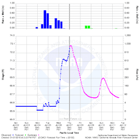
There have not been many floods during the drought years. The soil has been so parched that what little rain fell soaked into the ground, leaving little for surface runoff. The 2015-2016 water year has been different. November and December provided above-normal rainfall (and a Sierra snowpack), so when the January storms hit this week (the first attributed to El Nino), the ground was pretty well saturated. Close to 2 inches fell over the region on Tuesday and Wednesday, and the river peaked today at almost 1,000 cubic feet per second. As can be seen on the flood hydrograph below, the river will recede relatively quickly to tens of cubic feet per second within a day or so.
The last time Dry Creek really caught my attention this way was back in March 2011, when the discharge was around three times higher than it was today, at 3,000 cubic feet per second. Compare the difference in the picture below, taken from the same bridge. The river was even higher in the El Nino year of 1997, and with a probability of once in 500 years the creek may produce flows as great as 18,500 cubic feet per second. That would be something to see, but I wouldn't wish it on anyone.
Dry Creek in March 2011
The other unexpected event of the day was seeing a Red Fox out my office window. The fox lives on our campus so I've seen it two or three times before. It was running through an area slated to become an outdoor educational area for our Great Valley Museum of Natural History. The lab will emphasize the natural vegetation and animals of the valley. It was nice to see nature getting a bit of a head start!

Seeing these two different things reminded me that there is a small remnant of a natural ecosystem left in our valley, one that can never be completely obliterated by dams, farms, and cities. We can never truly control the rivers or droughts, and the tattered remnants of the original ecosystem will for the most part adapt and survive our invasion, albeit in small pockets here and there.

Wednesday, January 6, 2016

Dreams of Summer: Living Under the Threat of Destruction at Wupatki

The San Francisco Peaks, a gigantic stratovolcano, rises beyond the ruins of the Citadel at Wupatki National Monument.
There is a huge difference between living close to the Earth without advanced technology and living in a highly technological society. Well, lots of differences actually, but today I'm thinking about living in ignorance of geological hazards. The thought arose because of our visit to the rather fantastic pueblos of Wupatki National Monument in the region east of Grand Canyon. There are lots of archaeological remains of the people who lived in the Colorado Plateau over the last 12,000 years, but few of them are as spectacular as the pueblos that were built between 1,100 and 1,285 AD. Many, maybe most, were fortresses. Some of these people seemed to be living in fear.
The Citadel ruin at Wupatki is built on the eroded remains of a basalt lava flow.
There has been a mountain of speculation about why the Ancestral Pueblo people and other cultures took such a defensive posture in their architecture. It is well known that most of the Colorado Plateau was abandoned in the late 13th century, and the hypotheses are numerous. There were a series of droughts, including a 25-year-long monster. These was evidence of warfare in a few places. Soils had washed away in many places. There could have been religious or cultural forces in place that caused migrations. It's an interesting issue that will keep archaeologists busy for a long time.
The view of the San Francisco Peaks from the top of the Citadel ruin.
Archaeology played a special part of our summer field studies journey across the Colorado Plateau. Half our students were majors in the subject (or possessed a lot of interest in the subject) who were learning geology. And our geologists were learning archaeology. I've been doing joint trips with our anthropology professors for a decade now, and we find a lot of common scientific ground as we travel through this fascinating landscape.
The hundred room pueblo at Wupatki
Wupatki National Monument preserves structures and sites of numerous ancient cultures, but the most visible were built by the Sinagua people, whose descendants still live in the region (the Hopi, Zuni,  Pima, Tohono O'odham, and Yavapai people). The region was a crossroads of sorts, and direct evidence suggests habitation as early as 500 AD. People lived at the site for 600 years, perhaps never suspecting that they were living on volcanic ground.
That changed in 1085 AD or so when Sunset Crater, a basaltic cinder cone, erupted, sending out lava flows, cinders and ash over a region totaling about 800 square miles (the longest lava flow was 6 miles long). Lava flows covered several villages.

It's possible that some cultural recognition of volcanism existed in the stories and traditions of the people who lived in the path of destruction, but maybe not. Can you imagine the impact of seeing a volcanic eruption in progress for the first time as a people? What kind of stories would be told explaining the phenomenon? Many of the old ruins are built on older volcanic deposits. Did the logical thinkers among the people recognize in a flash the origin of the ground and rock on which their homes were constructed?

In any case, the region was abandoned for a few decades, but settlers came back, finding that the ash had rejuvenated the soils. A gift of the gods? One wonders. They lived and built homes in the region for two more centuries before leaving the land for other places. Although the abandonment was part of a regional pattern, one can wonder if those two centuries included a healthy fear of the fires from down below in the crust?
Sunset Crater, the youngest volcano in the San Francisco Peaks Volcanic Field. It erupted about 1085 AD
The Sinagua people of Wupatki may or may not have known about volcanoes prior to 1085 AD, but in our highly technological society, we understand a great deal about volcanoes, and geology has provided us the tools to figure out the probabilities of future eruptions. Likewise, we are able to calculate to a reasonable degree the probabilities of earthquakes within given time frames (over a 30 year period, for instance). We can calculate flood probabilities before a particular storm arrives.  But that also means we live with a certain amount of fear. This is good in the sense of allowing the society to prepare. But fear can also be manipulated.

I can imagine a shaman or other kind of leader of the Sinagua threatening his or her people with the return of the legendary fire gods of the volcano to achieve some nefarious end. Can we imagine anyone who would be tempted to manipulate scientific knowledge into a fear of volcanoes (can you say "SUPERVOLCANO" nice and loud?) or earthquakes (can you say CASCADIA?) to achieve influence and power?

Source: http://www.cosmostv.org/2014/08/yellowstone-super-volcanoresent-rumors.html (actually, this is good article)
Nah, I'm sure no one would fan the flames of fear in modern society...the internet and other mass media has brought knowledge and wisdom to us all.